Urganch geodata
Urganch (Xorazm) is a seat of a first-order administrative division; located in Uzbekistan in Asia/Samarkand (GMT+5) time zone. With population of 150,110 people, there are 11 cities with bigger population in this country. Compared to other cities in Uzbekistan, 83.3% of cities are located further ↓South; 87.9% of cities are located further →East and 86.2% of cities have higher elevation than Urganch. Note1


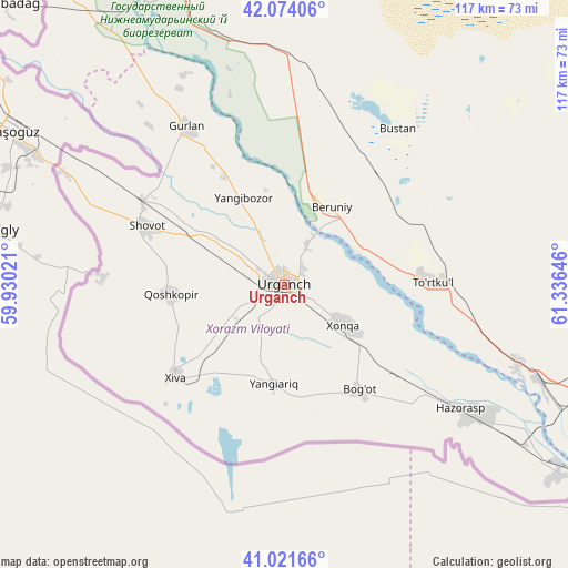
Urganch GPS coordinates[2]
41° 33' 0" North, 60° 37' 59.988" East
| Map corner | latitude | longitude |
|---|---|---|
| Upper-left | 42.07406°, | 59.93021° |
| Center: | 41.55°, | 60.63333° |
| Lower-right: | 41.02166°, | 61.33646° |
| Map W x H: | 117×117 km | = 72.7×72.7mi |
| max Lat: | 43.77877° ⇑16.7% North |
| Urganch: | 41.55° |
| min Lat: | ⇓83.3% South 37.22417° |
| min Long | Urganch | max Long |
| 58.84596° | 60.63333° | 72.76177° |
| W 12.1%⇐ | ⇒87.9% E |
Elevation
Elevation of Urganch is 105 m = 344 ft, and this is 328.8 m = 1079 ft below average elevation for this country.
| Max E: |
1464 m = 4803 ft | 86.2% |
| Avg. | 433.8 m = 1423 ft | |
| Urganch | 105 m = 344 ft | |
Min E: |
50 m = 164 ft | 13.8% |
See also: Urganch elevation on elevation.city.
Geographical zone
Urganch is located in North temperate zone (between Tropic of Cancer and the Arctic Circle). Distance of this Northern Tropic circle is 2014 km =1251.4 mi to South.| Distance of | km | miles | from Urganch |
|---|---|---|---|
| North Pole | 5387.1 | 3347.4 | to North |
| Arctic Circle | 2781.2 | 1728.2 | to North |
| Tropic Cancer | 2014 | 1251.4 | to South |
| Equator | 4619.9 | 2870.7 | to South |


Nearby cities:
15 places around Urganch: (largest is in red/bold)
• Beruniy
18.6 km =11.6 mi,  32°
32°
• Beruniy Shahri
19.4 km =12.1 mi, 31°
• Bo‘ston Shahri
42 km =26.1 mi,  38°
38°
• Gurlan
38.4 km =23.9 mi,  328°
328°
• Hazorasp
44.8 km =27.8 mi,  124°
124°
• Khiwa
29.5 km =18.3 mi,  229°
229°
• Khŭjayli
135.5 km =84.2 mi,  314°
314°
• Manghit
78.8 km =49 mi,  322°
322°
• Mang‘it Shahri
79.3 km =49.3 mi, 323°
• Novyy Turtkul’
31.9 km =19.8 mi,  90°
90°
• Nukus
131.3 km =81.6 mi, 319°
• Qŭshkŭpir
24 km =14.9 mi,  266°
266°
• Showot
29.9 km =18.6 mi,  293°
293°
• To‘rtko‘l Shahri
30.7 km =19.1 mi, 87°
• Xo‘jayli Shahri
137 km =85.1 mi, 314°
Sources, notices
• [Note1] Compared only with cities in Uzbekistan existing in our database
• [Src1] Map data: © OpenStreetMap contributors (CC-BY-SA)
• [Src2] Other city data from geonames.org with taken over terms of usage.
• [Src3] Geographical zone / Annual Mean Temperature by Robert A. Rohde @ Wikipedia
