Bag‘dod geodata
Bag‘dod (Fergana) is a seat of a second-order administrative division; located in Uzbekistan in Asia/Tashkent (GMT+5) time zone. In our database, there are 114 cities with bigger population. Compared to other cities in Uzbekistan, 56.3% of cities are located further ↑North; 75.9% of cities are located further ←West and 50.6% of cities have lower elevation than Bag‘dod. Note1


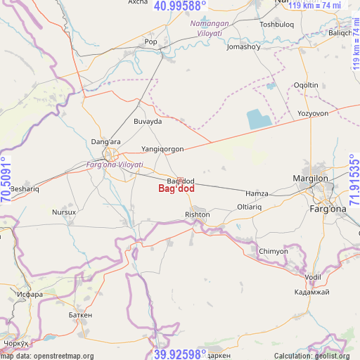
Bag‘dod GPS coordinates[2]
40° 27' 47.016" North, 71° 12' 43.992" East
| Map corner | latitude | longitude |
|---|---|---|
| Upper-left | 40.99588°, | 70.5091° |
| Center: | 40.46306°, | 71.21222° |
| Lower-right: | 39.92598°, | 71.91535° |
| Map W x H: | 119×119 km | = 73.9×73.9mi |
| max Lat: | 43.77877° ⇑56.3% North |
| Bag‘dod: | 40.46306° |
| min Lat: | ⇓43.7% South 37.22417° |
| min Long | Bag‘dod | max Long |
| 58.84596° | 71.21222° | 72.76177° |
| W 75.9%⇐ | ⇒24.1% E |
Elevation
Elevation of Bag‘dod is 419 m = 1375 ft, and this is 14.8 m = 49 ft below average elevation for this country.
| Max E: |
1464 m = 4803 ft | 49.4% |
| Avg. | 433.8 m = 1423 ft | |
| Bag‘dod | 419 m = 1375 ft | |
Min E: |
50 m = 164 ft | 50.6% |
See also: Uzbekistan elevation on elevation.city.
Geographical zone
Bag‘dod is located in North temperate zone (between Tropic of Cancer and the Arctic Circle). Distance of this Northern Tropic circle is 1893.2 km =1176.4 mi to South.| Distance of | km | miles | from Bag‘dod |
|---|---|---|---|
| North Pole | 5508 | 3422.5 | to North |
| Arctic Circle | 2902.1 | 1803.3 | to North |
| Tropic Cancer | 1893.2 | 1176.4 | to South |
| Equator | 4499.1 | 2795.6 | to South |


Nearby cities:
15 places around Bag‘dod: (largest is in red/bold)
• Dang‘ara
28.5 km =17.7 mi,  298°
298°
• Hamza
25.1 km =15.6 mi,  99°
99°
• Langar
38.4 km =23.9 mi,  80°
80°
• Marg‘ilon
43.4 km =27 mi,  88°
88°
• Navbahor
37.4 km =23.2 mi,  273°
273°
• Oltiariq
23.5 km =14.6 mi,  109°
109°
• Pop
46.5 km =28.9 mi,  349°
349°
• Pop Shahri
46.9 km =29.1 mi, 348°
• Qo‘qon
23.9 km =14.9 mi,  287°
287°
• Rishton
13.3 km =8.3 mi,  152°
152°
• Toshloq
47 km =29.2 mi, 88°
• Uchko‘prik
15.5 km =9.6 mi, 304°
• Yangi Marg‘ilon
43.1 km =26.8 mi, 95°
• Yangiqo‘rg‘on
11.5 km =7.1 mi,  331°
331°
• Yaypan
35 km =21.7 mi,  253°
253°
Sources, notices
• [Note1] Compared only with cities in Uzbekistan existing in our database
• [Src1] Map data: © OpenStreetMap contributors (CC-BY-SA)
• [Src2] Other city data from geonames.org with taken over terms of usage.
• [Src3] Geographical zone / Annual Mean Temperature by Robert A. Rohde @ Wikipedia
