Pop geodata
Pop (Namangan) is a populated place; located in Uzbekistan in Asia/Tashkent (GMT+5) time zone. With population of 22,122 people, there are 77 cities with bigger population in this country. Compared to other cities in Uzbekistan, 61.5% of cities are located further ↓South; 74.1% of cities are located further ←West and 53.4% of cities have lower elevation than Pop. Note1


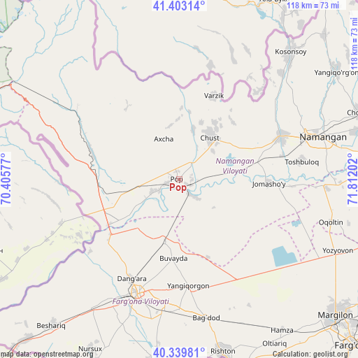
Pop GPS coordinates[2]
40° 52' 24.996" North, 71° 6' 32.004" East
| Map corner | latitude | longitude |
|---|---|---|
| Upper-left | 41.40314°, | 70.40577° |
| Center: | 40.87361°, | 71.10889° |
| Lower-right: | 40.33981°, | 71.81202° |
| Map W x H: | 118.2×118.2 km | = 73.4×73.4mi |
| max Lat: | 43.77877° ⇑38.5% North |
| Pop: | 40.87361° |
| min Lat: | ⇓61.5% South 37.22417° |
| min Long | Pop | max Long |
| 58.84596° | 71.10889° | 72.76177° |
| W 74.1%⇐ | ⇒25.9% E |
Elevation
Elevation of Pop is 440 m = 1444 ft, and this is 6.2 m = 20 ft above average elevation for this country.
| Max E: |
1464 m = 4803 ft | 46.6% |
| Pop | 440 m 1444 ft | |
| Avg. | 433.8 m = 1423 ft | |
Min E: |
50 m = 164 ft | 53.4% |
See also: Uzbekistan elevation on elevation.city.
Geographical zone
Pop is located in North temperate zone (between Tropic of Cancer and the Arctic Circle). Distance of this Northern Tropic circle is 1938.8 km =1204.7 mi to South.| Distance of | km | miles | from Pop |
|---|---|---|---|
| North Pole | 5462.3 | 3394.1 | to North |
| Arctic Circle | 2856.5 | 1774.9 | to North |
| Tropic Cancer | 1938.8 | 1204.7 | to South |
| Equator | 4544.7 | 2823.9 | to South |


Nearby cities:
15 places around Pop: (largest is in red/bold)
• Bag‘dod
46.5 km =28.9 mi,  169°
169°
• Chust
18 km =11.2 mi,  36°
36°
• Dang‘ara
36.1 km =22.4 mi,  206°
206°
• Kosonsoy
55.7 km =34.6 mi, 41°
• Kosonsoy Shahri
56.5 km =35.1 mi, 39°
• Namangan
49.3 km =30.6 mi,  73°
73°
• Navbahor
52.1 km =32.4 mi, 213°
• Oqoltin
51.7 km =32.1 mi,  105°
105°
• Pop Shahri
0.6 km =0.4 mi,  299°
299°
• Qo‘qon
40.8 km =25.4 mi,  200°
200°
• Toshbuloq
39.7 km =24.7 mi,  83°
83°
• To‘rqao‘rg‘on
36.6 km =22.7 mi, 67°
• Tŭragŭrghon Shahri
36.7 km =22.8 mi, 66°
• Uchko‘prik
37.1 km =23.1 mi,  186°
186°
• Yangiqo‘rg‘on
35.7 km =22.2 mi, 174°
Sources, notices
• [Note1] Compared only with cities in Uzbekistan existing in our database
• [Src1] Map data: © OpenStreetMap contributors (CC-BY-SA)
• [Src2] Other city data from geonames.org with taken over terms of usage.
• [Src3] Geographical zone / Annual Mean Temperature by Robert A. Rohde @ Wikipedia
