Güigüe geodata
Güigüe (Carabobo) is a seat of a second-order administrative division; located in Venezuela in America/Caracas (GMT-4) time zone. With population of 71,530 people, there are 57 cities with bigger population in this country. Compared to other cities in Venezuela, 60.8% of cities are located further ↓South; 60.3% of cities are located further ←West and 78.4% of cities have lower elevation than Güigüe. Note1


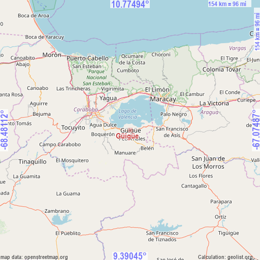
Güigüe GPS coordinates[2]
10° 5' 0.384" North, 67° 46' 40.764" West
| Map corner | latitude | longitude |
|---|---|---|
| Upper-left | 10.77494°, | -68.48112° |
| Center: | 10.08344°, | -67.77799° |
| Lower-right: | 9.39045°, | -67.07487° |
| Map W x H: | 153.9×153.9 km | = 95.6×95.6mi |
| max Lat: | 11.94788° ⇑39.2% North |
| Güigüe: | 10.08344° |
| min Lat: | ⇓60.8% South 1.92027° |
| min Long | Güigüe | max Long |
| -72.55212° | -67.77799° | -60.99778° |
| W 60.3%⇐ | ⇒39.7% E |
Elevation
Elevation of Güigüe is 590 m = 1936 ft, and this is 209.4 m = 687 ft above average elevation for this country.
| Max E: |
2986 m = 9797 ft | 21.6% |
| Güigüe | 590 m 1936 ft | |
| Avg. | 380.6 m = 1249 ft | |
Min E: |
-4 m = -13 ft | 78.4% |
See also: Güigüe elevation on elevation.city.
Geographical zone
Güigüe is located in North Torrid zone (between Equator and Tropic of Cancer). Distance of Equator is 1121.2 km =696.7 mi to South.| Distance of | km | miles | from Güigüe |
|---|---|---|---|
| North Pole | 8885.9 | 5521.4 | to North |
| Arctic Circle | 6280 | 3902.2 | to North |
| Tropic Cancer | 1484.7 | 922.5 | to North |
| Equator | 1121.2 | 696.7 | to South |


Nearby cities:
15 places around Güigüe: (largest is in red/bold)
• El Limón
29.4 km =18.3 mi,  32°
32°
• Guacara
19.2 km =11.9 mi,  325°
325°
• Los Guayos
21.1 km =13.1 mi,  303°
303°
• Maracay
26.5 km =16.5 mi,  50°
50°
• Mariara
24.5 km =15.2 mi,  15°
15°
• Naguanagua
32.4 km =20.1 mi,  306°
306°
• Palo Negro
27.7 km =17.2 mi,  68°
68°
• San Diego
27.5 km =17.1 mi,  315°
315°
• San Joaquín
19.8 km =12.3 mi,  355°
355°
• Santa Cruz
31 km =19.3 mi, 69°
• Santa Rita
27.5 km =17.1 mi,  60°
60°
• Tacarigua
15.5 km =9.6 mi,  271°
271°
• Tocuyito
31.9 km =19.8 mi,  276°
276°
• Valencia
26.6 km =16.5 mi,  289°
289°
• Villa de Cura
32 km =19.9 mi,  98°
98°
Sources, notices
• [Note1] Compared only with cities in Venezuela existing in our database
• [Src1] Map data: © OpenStreetMap contributors (CC-BY-SA)
• [Src2] Other city data from geonames.org with taken over terms of usage.
• [Src3] Geographical zone / Annual Mean Temperature by Robert A. Rohde @ Wikipedia
