El Limón geodata
El Limón (Aragua) is a seat of a second-order administrative division; located in Venezuela in America/Caracas (GMT-4) time zone. With population of 148,247 people, there are 29 cities with bigger population in this country. Compared to other cities in Venezuela, 74.6% of cities are located further ↓South; 61.6% of cities are located further ←West and 73.3% of cities have lower elevation than El Limón. Note1


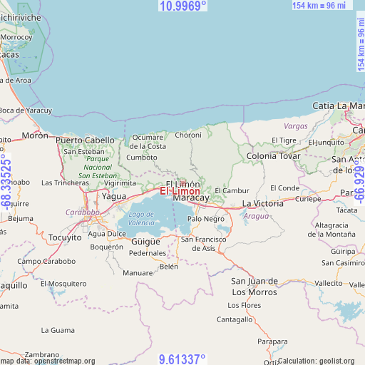
El Limón GPS coordinates[2]
10° 18' 21.204" North, 67° 37' 55.632" West
| Map corner | latitude | longitude |
|---|---|---|
| Upper-left | 10.9969°, | -68.33525° |
| Center: | 10.30589°, | -67.63212° |
| Lower-right: | 9.61337°, | -66.929° |
| Map W x H: | 153.8×153.8 km | = 95.6×95.6mi |
| max Lat: | 11.94788° ⇑25.4% North |
| El Limón: | 10.30589° |
| min Lat: | ⇓74.6% South 1.92027° |
| min Long | El Limón | max Long |
| -72.55212° | -67.63212° | -60.99778° |
| W 61.6%⇐ | ⇒38.4% E |
Elevation
Elevation of El Limón is 492 m = 1614 ft, and this is 111.4 m = 365 ft above average elevation for this country.
| Max E: |
2986 m = 9797 ft | 26.7% |
| El Limón | 492 m 1614 ft | |
| Avg. | 380.6 m = 1249 ft | |
Min E: |
-4 m = -13 ft | 73.3% |
See also: El Limón elevation on elevation.city.
Geographical zone
El Limón is located in North Torrid zone (between Equator and Tropic of Cancer). Distance of Equator is 1145.9 km =712 mi to South.| Distance of | km | miles | from El Limón |
|---|---|---|---|
| North Pole | 8861.2 | 5506.1 | to North |
| Arctic Circle | 6255.3 | 3886.9 | to North |
| Tropic Cancer | 1460 | 907.2 | to North |
| Equator | 1145.9 | 712 | to South |


Nearby cities:
15 places around El Limón: (largest is in red/bold)
• Cagua
23.1 km =14.4 mi,  125°
125°
• Guacara
28.2 km =17.5 mi,  251°
251°
• Güigüe
29.4 km =18.3 mi,  212°
212°
• La Victoria
34.1 km =21.2 mi,  104°
104°
• Maracay
9 km =5.6 mi,  150°
150°
• Mariara
9.4 km =5.8 mi,  262°
262°
• Ocumare de la Costa
22.8 km =14.2 mi,  319°
319°
• Palo Negro
17.7 km =11 mi, 146°
• San Diego
35.5 km =22.1 mi, 261°
• San Joaquín
18.4 km =11.4 mi, 254°
• San Mateo
25 km =15.5 mi,  114°
114°
• Santa Cruz
19.2 km =11.9 mi,  136°
136°
• Santa Rita
13.7 km =8.5 mi, 144°
• Turmero
19.3 km =12 mi,  116°
116°
• Villa de Cura
33.6 km =20.9 mi, 152°
Sources, notices
• [Note1] Compared only with cities in Venezuela existing in our database
• [Src1] Map data: © OpenStreetMap contributors (CC-BY-SA)
• [Src2] Other city data from geonames.org with taken over terms of usage.
• [Src3] Geographical zone / Annual Mean Temperature by Robert A. Rohde @ Wikipedia
