San Joaquín geodata
San Joaquín (Carabobo) is a seat of a second-order administrative division; located in Venezuela in America/Caracas (GMT-4) time zone. With population of 41,630 people, there are 81 cities with bigger population in this country. Compared to other cities in Venezuela, 72.8% of cities are located further ↓South; 60.1% of cities are located further ←West and 75.1% of cities have lower elevation than San Joaquín. Note1


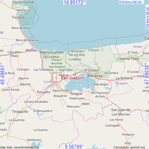
San Joaquín GPS coordinates[2]
10° 15' 38.196" North, 67° 47' 36.528" West
| Map corner | latitude | longitude |
|---|---|---|
| Upper-left | 10.95172°, | -68.49661° |
| Center: | 10.26061°, | -67.79348° |
| Lower-right: | 9.56799°, | -67.09036° |
| Map W x H: | 153.9×153.9 km | = 95.6×95.6mi |
| max Lat: | 11.94788° ⇑27.2% North |
| San Joaquín: | 10.26061° |
| min Lat: | ⇓72.8% South 1.92027° |
| min Long | San Joaquín | max Long |
| -72.55212° | -67.79348° | -60.99778° |
| W 60.1%⇐ | ⇒39.9% E |
Elevation
Elevation of San Joaquín is 533 m = 1749 ft, and this is 152.4 m = 500 ft above average elevation for this country.
| Max E: |
2986 m = 9797 ft | 24.9% |
| San Joaquín | 533 m 1749 ft | |
| Avg. | 380.6 m = 1249 ft | |
Min E: |
-4 m = -13 ft | 75.1% |
See also: San Joaquín elevation on elevation.city.
Geographical zone
San Joaquín is located in North Torrid zone (between Equator and Tropic of Cancer). Distance of Equator is 1140.9 km =708.9 mi to South.| Distance of | km | miles | from San Joaquín |
|---|---|---|---|
| North Pole | 8866.2 | 5509.2 | to North |
| Arctic Circle | 6260.3 | 3890 | to North |
| Tropic Cancer | 1465 | 910.3 | to North |
| Equator | 1140.9 | 708.9 | to South |


Nearby cities:
15 places around San Joaquín: (largest is in red/bold)
• El Limón
18.4 km =11.4 mi,  74°
74°
• Guacara
9.9 km =6.2 mi,  247°
247°
• Güigüe
19.8 km =12.3 mi,  175°
175°
• Los Guayos
17.7 km =11 mi,  243°
243°
• Maracay
22.3 km =13.9 mi,  97°
97°
• Mariara
9.1 km =5.7 mi, 65°
• Naguanagua
24.4 km =15.2 mi,  268°
268°
• Ocumare de la Costa
22.5 km =14 mi,  6°
6°
• Palo Negro
29.2 km =18.1 mi,  109°
109°
• Puerto Cabello
33.6 km =20.9 mi,  314°
314°
• San Diego
17.5 km =10.9 mi, 269°
• Santa Cruz
32.1 km =19.9 mi, 106°
• Santa Rita
26.3 km =16.3 mi, 103°
• Tacarigua
23.8 km =14.8 mi,  215°
215°
• Valencia
25.9 km =16.1 mi, 244°
Sources, notices
• [Note1] Compared only with cities in Venezuela existing in our database
• [Src1] Map data: © OpenStreetMap contributors (CC-BY-SA)
• [Src2] Other city data from geonames.org with taken over terms of usage.
• [Src3] Geographical zone / Annual Mean Temperature by Robert A. Rohde @ Wikipedia
