Bejuma geodata
Bejuma (Carabobo) is a seat of a second-order administrative division; located in Venezuela in America/Caracas (GMT-4) time zone. In our database, there are 108 cities with bigger population. Compared to other cities in Venezuela, 65.9% of cities are located further ↓South; 56.5% of cities are located further ←West and 80.9% of cities have lower elevation than Bejuma. Note1


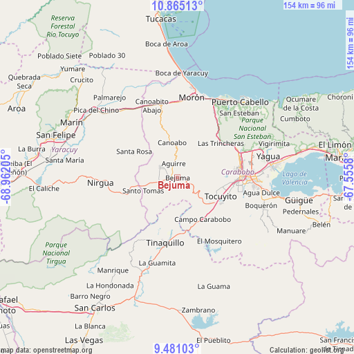
Bejuma GPS coordinates[2]
10° 10' 25.788" North, 68° 15' 32.112" West
| Map corner | latitude | longitude |
|---|---|---|
| Upper-left | 10.86513°, | -68.96205° |
| Center: | 10.17383°, | -68.25892° |
| Lower-right: | 9.48103°, | -67.5558° |
| Map W x H: | 153.9×153.9 km | = 95.6×95.6mi |
| max Lat: | 11.94788° ⇑34.1% North |
| Bejuma: | 10.17383° |
| min Lat: | ⇓65.9% South 1.92027° |
| min Long | Bejuma | max Long |
| -72.55212° | -68.25892° | -60.99778° |
| W 56.5%⇐ | ⇒43.5% E |
Elevation
Elevation of Bejuma is 675 m = 2215 ft, and this is 294.4 m = 966 ft above average elevation for this country.
| Max E: |
2986 m = 9797 ft | 19.1% |
| Bejuma | 675 m 2215 ft | |
| Avg. | 380.6 m = 1249 ft | |
Min E: |
-4 m = -13 ft | 80.9% |
See also: Venezuela elevation on elevation.city.
Geographical zone
Bejuma is located in North Torrid zone (between Equator and Tropic of Cancer). Distance of Equator is 1131.2 km =702.9 mi to South.| Distance of | km | miles | from Bejuma |
|---|---|---|---|
| North Pole | 8875.8 | 5515.2 | to North |
| Arctic Circle | 6270 | 3896 | to North |
| Tropic Cancer | 1474.7 | 916.3 | to North |
| Equator | 1131.2 | 702.9 | to South |


Nearby cities:
15 places around Bejuma: (largest is in red/bold)
• Farriar
46.5 km =28.9 mi,  315°
315°
• Guacara
42.2 km =26.2 mi,  82°
82°
• Los Guayos
35.1 km =21.8 mi,  87°
87°
• Macapo
43.5 km =27 mi,  206°
206°
• Miranda
14.9 km =9.3 mi,  260°
260°
• Montalbán
8.6 km =5.3 mi,  300°
300°
• Morón
35.4 km =22 mi,  10°
10°
• Naguanagua
28.1 km =17.5 mi,  70°
70°
• Nirgua
33.6 km =20.9 mi,  265°
265°
• Puerto Cabello
42.8 km =26.6 mi,  39°
39°
• San Diego
34.8 km =21.6 mi, 73°
• Tacarigua
38.4 km =23.9 mi,  104°
104°
• Tinaquillo
28.8 km =17.9 mi,  190°
190°
• Tocuyito
22 km =13.7 mi,  107°
107°
• Valencia
27.5 km =17.1 mi, 92°
Sources, notices
• [Note1] Compared only with cities in Venezuela existing in our database
• [Src1] Map data: © OpenStreetMap contributors (CC-BY-SA)
• [Src2] Other city data from geonames.org with taken over terms of usage.
• [Src3] Geographical zone / Annual Mean Temperature by Robert A. Rohde @ Wikipedia
