Puerto Cabello geodata
Puerto Cabello (Carabobo) is a seat of a second-order administrative division; located in Venezuela in America/Caracas (GMT-4) time zone. With population of 174,000 people, there are 25 cities with bigger population in this country. Compared to other cities in Venezuela, 81.2% of cities are located further ↓South; 58.3% of cities are located further ←West and 80.2% of cities have higher elevation than Puerto Cabello. Note1


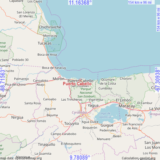
Puerto Cabello GPS coordinates[2]
10° 28' 23.016" North, 68° 0' 45" West
| Map corner | latitude | longitude |
|---|---|---|
| Upper-left | 11.16368°, | -68.71563° |
| Center: | 10.47306°, | -68.0125° |
| Lower-right: | 9.78089°, | -67.30938° |
| Map W x H: | 153.8×153.8 km | = 95.6×95.6mi |
| max Lat: | 11.94788° ⇑18.8% North |
| Puerto Cabello: | 10.47306° |
| min Lat: | ⇓81.2% South 1.92027° |
| min Long | Puerto Cabello | max Long |
| -72.55212° | -68.0125° | -60.99778° |
| W 58.3%⇐ | ⇒41.7% E |
Elevation
Elevation of Puerto Cabello is 49 m = 161 ft, and this is 331.6 m = 1088 ft below average elevation for this country.
| Max E: |
2986 m = 9797 ft | 80.2% |
| Avg. | 380.6 m = 1249 ft | |
| Puerto Cabello | 49 m = 161 ft | |
Min E: |
-4 m = -13 ft | 19.8% |
See also: Puerto Cabello elevation on elevation.city.
Geographical zone
Puerto Cabello is located in North Torrid zone (between Equator and Tropic of Cancer). Distance of Equator is 1164.5 km =723.6 mi to South.| Distance of | km | miles | from Puerto Cabello |
|---|---|---|---|
| North Pole | 8842.6 | 5494.5 | to North |
| Arctic Circle | 6236.7 | 3875.3 | to North |
| Tropic Cancer | 1441.4 | 895.6 | to North |
| Equator | 1164.5 | 723.6 | to South |


Nearby cities:
15 places around Puerto Cabello: (largest is in red/bold)
• Bejuma
42.8 km =26.6 mi,  219°
219°
• El Limón
45.6 km =28.3 mi,  114°
114°
• Guacara
31.2 km =19.4 mi,  151°
151°
• Los Guayos
32.6 km =20.3 mi,  165°
165°
• Mariara
37.8 km =23.5 mi,  121°
121°
• Montalbán
44.9 km =27.9 mi,  229°
229°
• Morón
20.6 km =12.8 mi,  274°
274°
• Naguanagua
24.1 km =15 mi,  181°
181°
• Ocumare de la Costa
26.7 km =16.6 mi,  92°
92°
• San Diego
24.5 km =15.2 mi,  164°
164°
• San Joaquín
33.6 km =20.9 mi,  134°
134°
• Tacarigua
44.2 km =27.5 mi, 166°
• Tocuyito
40.4 km =25.1 mi,  188°
188°
• Tucacas
49.1 km =30.5 mi,  315°
315°
• Valencia
34.6 km =21.5 mi, 179°
Sources, notices
• [Note1] Compared only with cities in Venezuela existing in our database
• [Src1] Map data: © OpenStreetMap contributors (CC-BY-SA)
• [Src2] Other city data from geonames.org with taken over terms of usage.
• [Src3] Geographical zone / Annual Mean Temperature by Robert A. Rohde @ Wikipedia
