Montalbán geodata
Montalbán (Carabobo) is a seat of a second-order administrative division; located in Venezuela in America/Caracas (GMT-4) time zone. In our database, there are 108 cities with bigger population. Compared to other cities in Venezuela, 68.4% of cities are located further ↓South; 55.2% of cities are located further ←West and 80.4% of cities have lower elevation than Montalbán. Note1


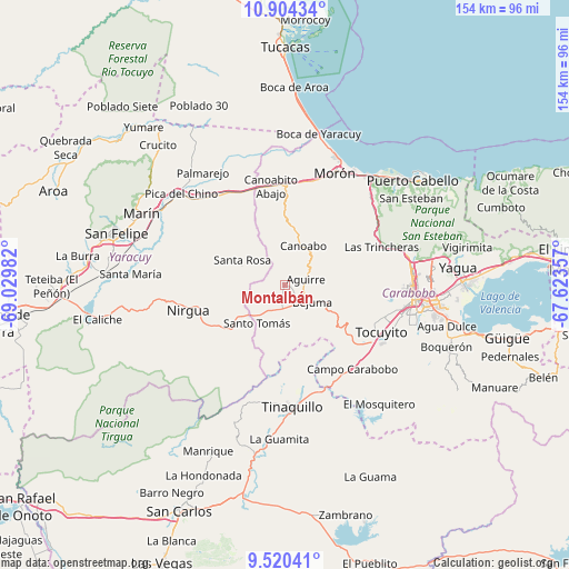
Montalbán GPS coordinates[2]
10° 12' 47.268" North, 68° 19' 36.084" West
| Map corner | latitude | longitude |
|---|---|---|
| Upper-left | 10.90434°, | -69.02982° |
| Center: | 10.21313°, | -68.32669° |
| Lower-right: | 9.52041°, | -67.62357° |
| Map W x H: | 153.9×153.9 km | = 95.6×95.6mi |
| max Lat: | 11.94788° ⇑31.6% North |
| Montalbán: | 10.21313° |
| min Lat: | ⇓68.4% South 1.92027° |
| min Long | Montalbán | max Long |
| -72.55212° | -68.32669° | -60.99778° |
| W 55.2%⇐ | ⇒44.8% E |
Elevation
Elevation of Montalbán is 669 m = 2195 ft, and this is 288.4 m = 946 ft above average elevation for this country.
| Max E: |
2986 m = 9797 ft | 19.6% |
| Montalbán | 669 m 2195 ft | |
| Avg. | 380.6 m = 1249 ft | |
Min E: |
-4 m = -13 ft | 80.4% |
See also: Venezuela elevation on elevation.city.
Geographical zone
Montalbán is located in North Torrid zone (between Equator and Tropic of Cancer). Distance of Equator is 1135.6 km =705.6 mi to South.| Distance of | km | miles | from Montalbán |
|---|---|---|---|
| North Pole | 8871.5 | 5512.5 | to North |
| Arctic Circle | 6265.6 | 3893.3 | to North |
| Tropic Cancer | 1470.3 | 913.6 | to North |
| Equator | 1135.6 | 705.6 | to South |


Nearby cities:
15 places around Montalbán: (largest is in red/bold)
• Bejuma
8.6 km =5.3 mi,  120°
120°
• Farriar
38.2 km =23.7 mi,  318°
318°
• Los Guayos
42.6 km =26.5 mi,  93°
93°
• Macapo
44.8 km =27.8 mi,  195°
195°
• Miranda
10.1 km =6.3 mi,  226°
226°
• Morón
33.4 km =20.8 mi,  24°
24°
• Naguanagua
34.3 km =21.3 mi,  81°
81°
• Nirgua
27 km =16.8 mi,  255°
255°
• Puerto Cabello
44.9 km =27.9 mi,  49°
49°
• San Diego
41.2 km =25.6 mi, 82°
• San Felipe
47.6 km =29.6 mi,  287°
287°
• Tacarigua
46.7 km =29 mi,  107°
107°
• Tinaquillo
32.8 km =20.4 mi,  175°
175°
• Tocuyito
30.4 km =18.9 mi, 111°
• Valencia
35.4 km =22 mi,  99°
99°
Sources, notices
• [Note1] Compared only with cities in Venezuela existing in our database
• [Src1] Map data: © OpenStreetMap contributors (CC-BY-SA)
• [Src2] Other city data from geonames.org with taken over terms of usage.
• [Src3] Geographical zone / Annual Mean Temperature by Robert A. Rohde @ Wikipedia
