Bút Sơn geodata
Bút Sơn (Thanh Hóa) is a seat of a second-order administrative division; located in Vietnam in Asia/Ho_Chi_Minh (GMT+7) time zone. In our database, there are 94 cities with bigger population. Compared to other cities in Vietnam, 57.9% of cities are located further ↓South; 60.7% of cities are located further →East and 71.9% of cities have higher elevation than Bút Sơn. Note1


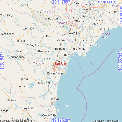
Bút Sơn GPS coordinates[2]
19° 51' 28.692" North, 105° 51' 17.352" East
| Map corner | latitude | longitude |
|---|---|---|
| Upper-left | 20.51789°, | 105.1517° |
| Center: | 19.85797°, | 105.85482° |
| Lower-right: | 19.19529°, | 106.55795° |
| Map W x H: | 147.1×147.1 km | = 91.4×91.4mi |
| max Lat: | 23.27841° ⇑42.1% North |
| Bút Sơn: | 19.85797° |
| min Lat: | ⇓57.9% South 8.65724° |
| min Long | Bút Sơn | max Long |
| 102.4579° | 105.85482° | 112.72541° |
| W 39.3%⇐ | ⇒60.7% E |
Elevation
Elevation of Bút Sơn is 8 m = 26 ft, and this is 121.5 m = 399 ft below average elevation for this country.
| Max E: |
1592 m = 5223 ft | 71.9% |
| Avg. | 129.5 m = 425 ft | |
| Bút Sơn | 8 m = 26 ft | |
Min E: |
-1 m = -3 ft | 28.1% |
See also: Vietnam elevation on elevation.city.
Geographical zone
Bút Sơn is located in North Torrid zone (between Equator and Tropic of Cancer). Distance of this Northern Tropic circle is 397.9 km =247.2 mi to North.| Distance of | km | miles | from Bút Sơn |
|---|---|---|---|
| North Pole | 7799.1 | 4846.1 | to North |
| Arctic Circle | 5193.2 | 3226.9 | to North |
| Tropic Cancer | 397.9 | 247.2 | to North |
| Equator | 2208 | 1372 | to South |


Nearby cities:
15 places around Bút Sơn: (largest is in red/bold)
• Bỉm Sơn
24.5 km =15.2 mi,  1°
1°
• Hà Trung
17.2 km =10.7 mi,  359°
359°
• Hậu Lộc
7.1 km =4.4 mi,  27°
27°
• Kim Tân
35.7 km =22.2 mi,  328°
328°
• Nga Sơn
20.5 km =12.7 mi,  36°
36°
• Nông Cống
33.7 km =20.9 mi,  219°
219°
• Phát Diệm
35.2 km =21.9 mi, 42°
• Quán Lào
24.8 km =15.4 mi,  300°
300°
• Quảng Xương
16.2 km =10.1 mi,  207°
207°
• Rừng Thông
13.5 km =8.4 mi,  251°
251°
• Tam Điệp
33.8 km =21 mi,  11°
11°
• Thanh Hóa
11.2 km =7 mi,  235°
235°
• Triệu Sơn
26.6 km =16.5 mi,  260°
260°
• Vĩnh Lộc
33.2 km =20.6 mi,  311°
311°
• Vạn Hà
18.7 km =11.6 mi,  279°
279°
Sources, notices
• [Note1] Compared only with cities in Vietnam existing in our database
• [Src1] Map data: © OpenStreetMap contributors (CC-BY-SA)
• [Src2] Other city data from geonames.org with taken over terms of usage.
• [Src3] Geographical zone / Annual Mean Temperature by Robert A. Rohde @ Wikipedia
