Bỉm Sơn geodata
Bỉm Sơn (Thanh Hóa) is a populated place; located in Vietnam in Asia/Ho_Chi_Minh (GMT+7) time zone. With population of 53,754 people, there are 55 cities with bigger population in this country. Compared to other cities in Vietnam, 59.4% of cities are located further ↓South; 60.5% of cities are located further →East and 75% of cities have higher elevation than Bỉm Sơn. Note1


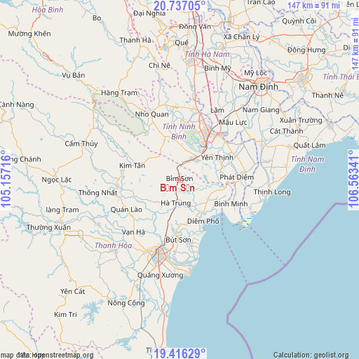
Bỉm Sơn GPS coordinates[2]
20° 4' 41.016" North, 105° 51' 37.008" East
| Map corner | latitude | longitude |
|---|---|---|
| Upper-left | 20.73705°, | 105.15716° |
| Center: | 20.07806°, | 105.86028° |
| Lower-right: | 19.41629°, | 106.56341° |
| Map W x H: | 146.9×146.9 km | = 91.3×91.3mi |
| max Lat: | 23.27841° ⇑40.6% North |
| Bỉm Sơn: | 20.07806° |
| min Lat: | ⇓59.4% South 8.65724° |
| min Long | Bỉm Sơn | max Long |
| 102.4579° | 105.86028° | 112.72541° |
| W 39.5%⇐ | ⇒60.5% E |
Elevation
Elevation of Bỉm Sơn is 7 m = 23 ft, and this is 122.5 m = 402 ft below average elevation for this country.
| Max E: |
1592 m = 5223 ft | 75% |
| Avg. | 129.5 m = 425 ft | |
| Bỉm Sơn | 7 m = 23 ft | |
Min E: |
-1 m = -3 ft | 25% |
See also: Bỉm Sơn elevation on elevation.city.
Geographical zone
Bỉm Sơn is located in North Torrid zone (between Equator and Tropic of Cancer). Distance of this Northern Tropic circle is 373.4 km =232 mi to North.| Distance of | km | miles | from Bỉm Sơn |
|---|---|---|---|
| North Pole | 7774.6 | 4830.9 | to North |
| Arctic Circle | 5168.7 | 3211.7 | to North |
| Tropic Cancer | 373.4 | 232 | to North |
| Equator | 2232.5 | 1387.2 | to South |


Nearby cities:
15 places around Bỉm Sơn: (largest is in red/bold)
• Bút Sơn
24.5 km =15.2 mi,  181°
181°
• Hà Trung
7.3 km =4.5 mi,  185°
185°
• Hậu Lộc
18.4 km =11.4 mi,  171°
171°
• Kim Tân
20.3 km =12.6 mi,  286°
286°
• Nga Sơn
13.9 km =8.6 mi,  124°
124°
• Nho Quan
29.5 km =18.3 mi,  337°
337°
• Ninh Bình
23.6 km =14.7 mi,  31°
31°
• Phát Diệm
23.3 km =14.5 mi,  86°
86°
• Quán Lào
24.9 km =15.5 mi,  241°
241°
• Tam Điệp
10.6 km =6.6 mi, 34°
• Thiên Tồn
26.4 km =16.4 mi,  21°
21°
• Vĩnh Lộc
25.7 km =16 mi,  264°
264°
• Vạn Hà
28.5 km =17.7 mi,  221°
221°
• Yên Ninh
24.1 km =15 mi,  60°
60°
• Yên Thịnh
18 km =11.2 mi, 58°
Sources, notices
• [Note1] Compared only with cities in Vietnam existing in our database
• [Src1] Map data: © OpenStreetMap contributors (CC-BY-SA)
• [Src2] Other city data from geonames.org with taken over terms of usage.
• [Src3] Geographical zone / Annual Mean Temperature by Robert A. Rohde @ Wikipedia
