Vĩnh Lộc geodata
Vĩnh Lộc (Thanh Hóa) is a seat of a second-order administrative division; located in Vietnam in Asia/Ho_Chi_Minh (GMT+7) time zone. In our database, there are 94 cities with bigger population. Compared to other cities in Vietnam, 59.2% of cities are located further ↓South; 72.6% of cities are located further →East and 59.2% of cities have lower elevation than Vĩnh Lộc. Note1


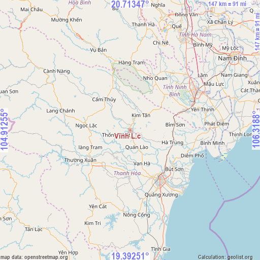
Vĩnh Lộc GPS coordinates[2]
20° 3' 15.768" North, 105° 36' 56.412" East
| Map corner | latitude | longitude |
|---|---|---|
| Upper-left | 20.71347°, | 104.91255° |
| Center: | 20.05438°, | 105.61567° |
| Lower-right: | 19.39251°, | 106.3188° |
| Map W x H: | 146.9×146.9 km | = 91.3×91.3mi |
| max Lat: | 23.27841° ⇑40.8% North |
| Vĩnh Lộc: | 20.05438° |
| min Lat: | ⇓59.2% South 8.65724° |
| min Long | Vĩnh Lộc | max Long |
| 102.4579° | 105.61567° | 112.72541° |
| W 27.4%⇐ | ⇒72.6% E |
Elevation
Elevation of Vĩnh Lộc is 22 m = 72 ft, and this is 107.5 m = 353 ft below average elevation for this country.
| Max E: |
1592 m = 5223 ft | 40.8% |
| Avg. | 129.5 m = 425 ft | |
| Vĩnh Lộc | 22 m = 72 ft | |
Min E: |
-1 m = -3 ft | 59.2% |
See also: Vietnam elevation on elevation.city.
Geographical zone
Vĩnh Lộc is located in North Torrid zone (between Equator and Tropic of Cancer). Distance of this Northern Tropic circle is 376.1 km =233.7 mi to North.| Distance of | km | miles | from Vĩnh Lộc |
|---|---|---|---|
| North Pole | 7777.2 | 4832.5 | to North |
| Arctic Circle | 5171.3 | 3213.3 | to North |
| Tropic Cancer | 376.1 | 233.7 | to North |
| Equator | 2229.8 | 1385.5 | to South |


Nearby cities:
15 places around Vĩnh Lộc: (largest is in red/bold)
• Bút Sơn
33.2 km =20.6 mi,  131°
131°
• Bỉm Sơn
25.7 km =16 mi,  84°
84°
• Cẩm Thủy
23 km =14.3 mi,  318°
318°
• Hà Trung
25.2 km =15.7 mi,  100°
100°
• Hậu Lộc
32.3 km =20.1 mi,  118°
118°
• Kim Tân
10.5 km =6.5 mi,  35°
35°
• Ngọc Lặc
26.2 km =16.3 mi,  279°
279°
• Nho Quan
33.1 km =20.6 mi,  25°
25°
• Quán Lào
9.9 km =6.2 mi,  158°
158°
• Rừng Thông
28.9 km =18 mi,  154°
154°
• Thanh Hóa
32.4 km =20.1 mi, 150°
• Thường Xuân
32.7 km =20.3 mi,  239°
239°
• Thọ Xuân
16.8 km =10.4 mi,  215°
215°
• Triệu Sơn
26.2 km =16.3 mi,  182°
182°
• Vạn Hà
19.8 km =12.3 mi, 160°
Sources, notices
• [Note1] Compared only with cities in Vietnam existing in our database
• [Src1] Map data: © OpenStreetMap contributors (CC-BY-SA)
• [Src2] Other city data from geonames.org with taken over terms of usage.
• [Src3] Geographical zone / Annual Mean Temperature by Robert A. Rohde @ Wikipedia
