Hàng Trạm geodata
Hàng Trạm (Hòa Bình) is a seat of a second-order administrative division; located in Vietnam in Asia/Ho_Chi_Minh (GMT+7) time zone. In our database, there are 94 cities with bigger population. Compared to other cities in Vietnam, 63.5% of cities are located further ↓South; 72.4% of cities are located further →East and 68.2% of cities have lower elevation than Hàng Trạm. Note1


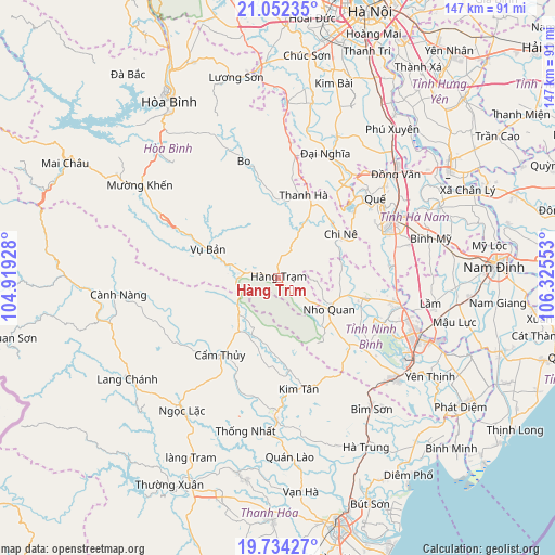
Hàng Trạm GPS coordinates[2]
20° 23' 40.992" North, 105° 37' 20.64" East
| Map corner | latitude | longitude |
|---|---|---|
| Upper-left | 21.05235°, | 104.91928° |
| Center: | 20.39472°, | 105.6224° |
| Lower-right: | 19.73427°, | 106.32553° |
| Map W x H: | 146.6×146.6 km | = 91.1×91.1mi |
| max Lat: | 23.27841° ⇑36.5% North |
| Hàng Trạm: | 20.39472° |
| min Lat: | ⇓63.5% South 8.65724° |
| min Long | Hàng Trạm | max Long |
| 102.4579° | 105.6224° | 112.72541° |
| W 27.6%⇐ | ⇒72.4% E |
Elevation
Elevation of Hàng Trạm is 49 m = 161 ft, and this is 80.5 m = 264 ft below average elevation for this country.
| Max E: |
1592 m = 5223 ft | 31.8% |
| Avg. | 129.5 m = 425 ft | |
| Hàng Trạm | 49 m = 161 ft | |
Min E: |
-1 m = -3 ft | 68.2% |
See also: Vietnam elevation on elevation.city.
Geographical zone
Hàng Trạm is located in North Torrid zone (between Equator and Tropic of Cancer). Distance of this Northern Tropic circle is 338.2 km =210.1 mi to North.| Distance of | km | miles | from Hàng Trạm |
|---|---|---|---|
| North Pole | 7739.4 | 4809 | to North |
| Arctic Circle | 5133.5 | 3189.8 | to North |
| Tropic Cancer | 338.2 | 210.1 | to North |
| Equator | 2267.7 | 1409.1 | to South |


Nearby cities:
15 places around Hàng Trạm: (largest is in red/bold)
• Bo
32.2 km =20 mi,  343°
343°
• Chi Nê
19.4 km =12.1 mi,  56°
56°
• Cẩm Thủy
26.1 km =16.2 mi,  217°
217°
• Kim Tân
29.9 km =18.6 mi,  169°
169°
• Me
22.9 km =14.2 mi,  103°
103°
• Nho Quan
15.7 km =9.8 mi,  120°
120°
• Ninh Bình
40.2 km =25 mi,  112°
112°
• Phủ Lý
34.5 km =21.4 mi, 60°
• Quế
33.3 km =20.7 mi,  51°
51°
• Tam Điệp
40.6 km =25.2 mi,  130°
130°
• Thanh Lưu
35.5 km =22.1 mi,  75°
75°
• Thiên Tồn
36 km =22.4 mi, 107°
• Vĩnh Lộc
37.8 km =23.5 mi,  181°
181°
• Vụ Bản
20.2 km =12.6 mi,  292°
292°
• Đại Nghĩa
34.9 km =21.7 mi,  21°
21°
Sources, notices
• [Note1] Compared only with cities in Vietnam existing in our database
• [Src1] Map data: © OpenStreetMap contributors (CC-BY-SA)
• [Src2] Other city data from geonames.org with taken over terms of usage.
• [Src3] Geographical zone / Annual Mean Temperature by Robert A. Rohde @ Wikipedia
