Thanh Lưu geodata
Thanh Lưu (Hà Nam) is a seat of a second-order administrative division; located in Vietnam in Asia/Ho_Chi_Minh (GMT+7) time zone. In our database, there are 94 cities with bigger population. Compared to other cities in Vietnam, 64.6% of cities are located further ↓South; 57.7% of cities are located further →East and 80.8% of cities have higher elevation than Thanh Lưu. Note1


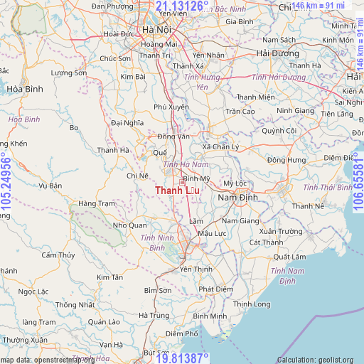
Thanh Lưu GPS coordinates[2]
20° 28' 26.328" North, 105° 57' 9.648" East
| Map corner | latitude | longitude |
|---|---|---|
| Upper-left | 21.13126°, | 105.24956° |
| Center: | 20.47398°, | 105.95268° |
| Lower-right: | 19.81387°, | 106.65581° |
| Map W x H: | 146.5×146.5 km | = 91×91mi |
| max Lat: | 23.27841° ⇑35.4% North |
| Thanh Lưu: | 20.47398° |
| min Lat: | ⇓64.6% South 8.65724° |
| min Long | Thanh Lưu | max Long |
| 102.4579° | 105.95268° | 112.72541° |
| W 42.3%⇐ | ⇒57.7% E |
Elevation
Elevation of Thanh Lưu is 6 m = 20 ft, and this is 123.5 m = 405 ft below average elevation for this country.
| Max E: |
1592 m = 5223 ft | 80.8% |
| Avg. | 129.5 m = 425 ft | |
| Thanh Lưu | 6 m = 20 ft | |
Min E: |
-1 m = -3 ft | 19.2% |
See also: Vietnam elevation on elevation.city.
Geographical zone
Thanh Lưu is located in North Torrid zone (between Equator and Tropic of Cancer). Distance of this Northern Tropic circle is 329.4 km =204.7 mi to North.| Distance of | km | miles | from Thanh Lưu |
|---|---|---|---|
| North Pole | 7730.6 | 4803.6 | to North |
| Arctic Circle | 5124.7 | 3184.3 | to North |
| Tropic Cancer | 329.4 | 204.7 | to North |
| Equator | 2276.5 | 1414.6 | to South |


Nearby cities:
15 places around Thanh Lưu: (largest is in red/bold)
• Bình Mỹ
6.2 km =3.9 mi,  72°
72°
• Chi Nê
18.3 km =11.4 mi,  275°
275°
• Gôi
20.4 km =12.7 mi,  140°
140°
• Hòa Mạc
19 km =11.8 mi,  11°
11°
• Hưng Yên
21.7 km =13.5 mi,  28°
28°
• Lâm
17.4 km =10.8 mi,  159°
159°
• Me
18.6 km =11.6 mi,  220°
220°
• Mỹ Lộc
16 km =9.9 mi,  103°
103°
• Nam Định
23.8 km =14.8 mi, 100°
• Nho Quan
26.8 km =16.7 mi,  231°
231°
• Ninh Bình
24.2 km =15 mi,  173°
173°
• Phủ Lý
9 km =5.6 mi,  332°
332°
• Quế
14.5 km =9 mi,  324°
324°
• Thiên Tồn
19.5 km =12.1 mi,  180°
180°
• Vĩnh Trụ
12.4 km =7.7 mi,  39°
39°
Sources, notices
• [Note1] Compared only with cities in Vietnam existing in our database
• [Src1] Map data: © OpenStreetMap contributors (CC-BY-SA)
• [Src2] Other city data from geonames.org with taken over terms of usage.
• [Src3] Geographical zone / Annual Mean Temperature by Robert A. Rohde @ Wikipedia
