Gôi geodata
Gôi (Nam Định) is a seat of a second-order administrative division; located in Vietnam in Asia/Ho_Chi_Minh (GMT+7) time zone. In our database, there are 94 cities with bigger population. Compared to other cities in Vietnam, 62.6% of cities are located further ↓South; 51.5% of cities are located further →East and 92.5% of cities have higher elevation than Gôi. Note1


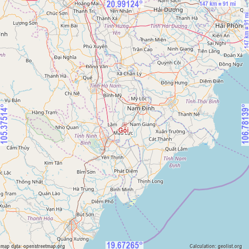
Gôi GPS coordinates[2]
20° 20' 0.06" North, 106° 4' 41.736" East
| Map corner | latitude | longitude |
|---|---|---|
| Upper-left | 20.99124°, | 105.37514° |
| Center: | 20.33335°, | 106.07826° |
| Lower-right: | 19.67265°, | 106.78139° |
| Map W x H: | 146.6×146.6 km | = 91.1×91.1mi |
| max Lat: | 23.27841° ⇑37.4% North |
| Gôi: | 20.33335° |
| min Lat: | ⇓62.6% South 8.65724° |
| min Long | Gôi | max Long |
| 102.4579° | 106.07826° | 112.72541° |
| W 48.5%⇐ | ⇒51.5% E |
Elevation
Elevation of Gôi is 4 m = 13 ft, and this is 125.5 m = 412 ft below average elevation for this country.
| Max E: |
1592 m = 5223 ft | 92.5% |
| Avg. | 129.5 m = 425 ft | |
| Gôi | 4 m = 13 ft | |
Min E: |
-1 m = -3 ft | 7.5% |
See also: Vietnam elevation on elevation.city.
Geographical zone
Gôi is located in North Torrid zone (between Equator and Tropic of Cancer). Distance of this Northern Tropic circle is 345.1 km =214.4 mi to North.| Distance of | km | miles | from Gôi |
|---|---|---|---|
| North Pole | 7746.2 | 4813.3 | to North |
| Arctic Circle | 5140.3 | 3194 | to North |
| Tropic Cancer | 345.1 | 214.4 | to North |
| Equator | 2260.9 | 1404.9 | to South |


Nearby cities:
15 places around Gôi: (largest is in red/bold)
• Bình Mỹ
19 km =11.8 mi,  337°
337°
• Cổ Lễ
19.6 km =12.2 mi,  93°
93°
• Lien De
16.9 km =10.5 mi,  137°
137°
• Lâm
6.9 km =4.3 mi,  264°
264°
• Me
25.3 km =15.7 mi,  273°
273°
• Mỹ Lộc
12.2 km =7.6 mi,  11°
11°
• Nam Giang
10.4 km =6.5 mi, 90°
• Nam Định
15.2 km =9.4 mi,  42°
42°
• Ninh Bình
13.3 km =8.3 mi,  230°
230°
• Thanh Lưu
20.4 km =12.7 mi,  320°
320°
• Thiên Tồn
13.7 km =8.5 mi,  253°
253°
• Vĩnh Trụ
25.8 km =16 mi,  348°
348°
• Vũ Thư
25 km =15.5 mi,  62°
62°
• Yên Ninh
16.7 km =10.4 mi,  186°
186°
• Yên Thịnh
20.4 km =12.7 mi,  201°
201°
Sources, notices
• [Note1] Compared only with cities in Vietnam existing in our database
• [Src1] Map data: © OpenStreetMap contributors (CC-BY-SA)
• [Src2] Other city data from geonames.org with taken over terms of usage.
• [Src3] Geographical zone / Annual Mean Temperature by Robert A. Rohde @ Wikipedia
