Mỹ Lộc geodata
Mỹ Lộc (Nam Định) is a seat of a second-order administrative division; located in Vietnam in Asia/Ho_Chi_Minh (GMT+7) time zone. In our database, there are 94 cities with bigger population. Compared to other cities in Vietnam, 64.1% of cities are located further ↓South; 50.6% of cities are located further →East and 92.5% of cities have higher elevation than Mỹ Lộc. Note1


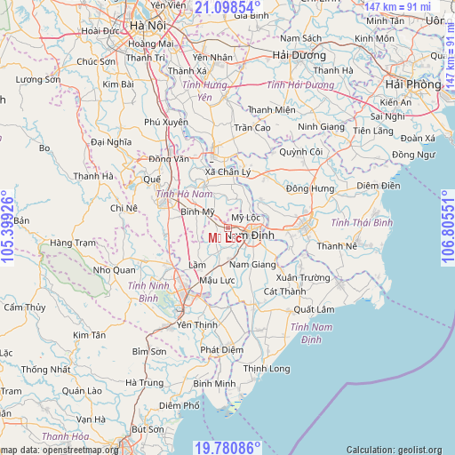
Mỹ Lộc GPS coordinates[2]
20° 26' 27.996" North, 106° 6' 8.568" East
| Map corner | latitude | longitude |
|---|---|---|
| Upper-left | 21.09854°, | 105.39926° |
| Center: | 20.44111°, | 106.10238° |
| Lower-right: | 19.78086°, | 106.80551° |
| Map W x H: | 146.5×146.5 km | = 91×91mi |
| max Lat: | 23.27841° ⇑35.9% North |
| Mỹ Lộc: | 20.44111° |
| min Lat: | ⇓64.1% South 8.65724° |
| min Long | Mỹ Lộc | max Long |
| 102.4579° | 106.10238° | 112.72541° |
| W 49.4%⇐ | ⇒50.6% E |
Elevation
Elevation of Mỹ Lộc is 4 m = 13 ft, and this is 125.5 m = 412 ft below average elevation for this country.
| Max E: |
1592 m = 5223 ft | 92.5% |
| Avg. | 129.5 m = 425 ft | |
| Mỹ Lộc | 4 m = 13 ft | |
Min E: |
-1 m = -3 ft | 7.5% |
See also: Vietnam elevation on elevation.city.
Geographical zone
Mỹ Lộc is located in North Torrid zone (between Equator and Tropic of Cancer). Distance of this Northern Tropic circle is 333.1 km =207 mi to North.| Distance of | km | miles | from Mỹ Lộc |
|---|---|---|---|
| North Pole | 7734.2 | 4805.8 | to North |
| Arctic Circle | 5128.3 | 3186.6 | to North |
| Tropic Cancer | 333.1 | 207 | to North |
| Equator | 2272.8 | 1412.3 | to South |


Nearby cities:
15 places around Mỹ Lộc: (largest is in red/bold)
• Bình Mỹ
11.2 km =7 mi,  299°
299°
• Cổ Lễ
21.5 km =13.4 mi,  127°
127°
• Gôi
12.2 km =7.6 mi,  191°
191°
• Hưng Hà
20.9 km =13 mi,  37°
37°
• Hưng Yên
23.4 km =14.5 mi,  346°
346°
• Lâm
15.7 km =9.8 mi,  216°
216°
• Nam Giang
14.3 km =8.9 mi,  146°
146°
• Nam Định
7.8 km =4.8 mi,  95°
95°
• Ninh Bình
24 km =14.9 mi,  212°
212°
• Phủ Lý
22.9 km =14.2 mi, 300°
• Thanh Lưu
16 km =9.9 mi,  283°
283°
• Thiên Tồn
22.3 km =13.9 mi, 224°
• Thái Bình
24.8 km =15.4 mi,  87°
87°
• Vĩnh Trụ
15.3 km =9.5 mi,  329°
329°
• Vũ Thư
19.7 km =12.2 mi, 91°
Sources, notices
• [Note1] Compared only with cities in Vietnam existing in our database
• [Src1] Map data: © OpenStreetMap contributors (CC-BY-SA)
• [Src2] Other city data from geonames.org with taken over terms of usage.
• [Src3] Geographical zone / Annual Mean Temperature by Robert A. Rohde @ Wikipedia
