Phú Thái geodata
Phú Thái (Hải Dương) is a seat of a second-order administrative division; located in Vietnam in Asia/Ho_Chi_Minh (GMT+7) time zone. In our database, there are 94 cities with bigger population. Compared to other cities in Vietnam, 73.2% of cities are located further ↓South; 62.8% of cities are located further ←West and 80.8% of cities have higher elevation than Phú Thái. Note1


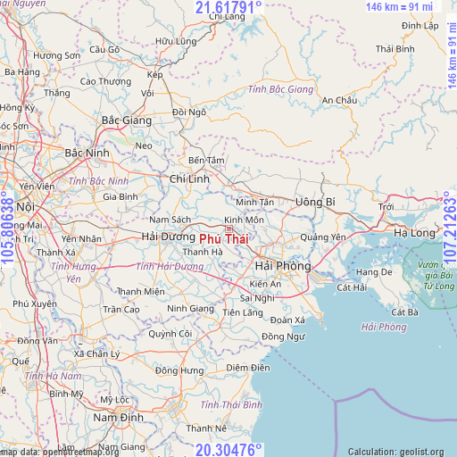
Phú Thái GPS coordinates[2]
20° 57' 46.008" North, 106° 30' 34.2" East
| Map corner | latitude | longitude |
|---|---|---|
| Upper-left | 21.61791°, | 105.80638° |
| Center: | 20.96278°, | 106.5095° |
| Lower-right: | 20.30476°, | 107.21263° |
| Map W x H: | 146×146 km | = 90.7×90.7mi |
| max Lat: | 23.27841° ⇑26.8% North |
| Phú Thái: | 20.96278° |
| min Lat: | ⇓73.2% South 8.65724° |
| min Long | Phú Thái | max Long |
| 102.4579° | 106.5095° | 112.72541° |
| W 62.8%⇐ | ⇒37.2% E |
Elevation
Elevation of Phú Thái is 6 m = 20 ft, and this is 123.5 m = 405 ft below average elevation for this country.
| Max E: |
1592 m = 5223 ft | 80.8% |
| Avg. | 129.5 m = 425 ft | |
| Phú Thái | 6 m = 20 ft | |
Min E: |
-1 m = -3 ft | 19.2% |
See also: Vietnam elevation on elevation.city.
Geographical zone
Phú Thái is located in North Torrid zone (between Equator and Tropic of Cancer). Distance of this Northern Tropic circle is 275.1 km =170.9 mi to North.| Distance of | km | miles | from Phú Thái |
|---|---|---|---|
| North Pole | 7676.2 | 4769.8 | to North |
| Arctic Circle | 5070.3 | 3150.5 | to North |
| Tropic Cancer | 275.1 | 170.9 | to North |
| Equator | 2330.8 | 1448.3 | to South |


Nearby cities:
15 places around Phú Thái: (largest is in red/bold)
• An Dương
15.4 km =9.6 mi,  135°
135°
• An Lão
16.3 km =10.1 mi,  162°
162°
• Gia Lộc
24.2 km =15 mi,  244°
244°
• Haiphong
21.1 km =13.1 mi,  121°
121°
• Hải Dương
18.5 km =11.5 mi,  262°
262°
• Kinh Môn
5.6 km =3.5 mi,  57°
57°
• Lai Cách
27.4 km =17 mi, 262°
• Nam Sách
18.3 km =11.4 mi,  280°
280°
• Ninh Giang
28.3 km =17.6 mi,  204°
204°
• Núi Đèo
17.9 km =11.1 mi,  107°
107°
• Núi Đối
28.8 km =17.9 mi, 144°
• Thanh Hà
11.3 km =7 mi,  230°
230°
• Thành Phố Uông Bí
28.2 km =17.5 mi,  73°
73°
• Tiên Lãng
26.9 km =16.7 mi,  170°
170°
• Tứ Kỳ
19.2 km =11.9 mi,  213°
213°
Sources, notices
• [Note1] Compared only with cities in Vietnam existing in our database
• [Src1] Map data: © OpenStreetMap contributors (CC-BY-SA)
• [Src2] Other city data from geonames.org with taken over terms of usage.
• [Src3] Geographical zone / Annual Mean Temperature by Robert A. Rohde @ Wikipedia
