Haiphong geodata
Haiphong is a seat of a first-order administrative division; located in Vietnam in Asia/Ho_Chi_Minh (GMT+7) time zone. With population of 602,695 people, there are 3 cities with bigger population in this country. Compared to other cities in Vietnam, 70.3% of cities are located further ↓South; 68.8% of cities are located further ←West and 54.8% of cities have higher elevation than Haiphong. Note1


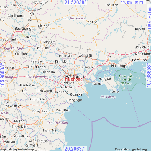
Haiphong GPS coordinates[2]
20° 51' 53.316" North, 106° 41' 0.42" East
| Map corner | latitude | longitude |
|---|---|---|
| Upper-left | 21.52038°, | 105.98033° |
| Center: | 20.86481°, | 106.68345° |
| Lower-right: | 20.20637°, | 107.38658° |
| Map W x H: | 146.1×146.1 km | = 90.8×90.8mi |
| max Lat: | 23.27841° ⇑29.7% North |
| Haiphong: | 20.86481° |
| min Lat: | ⇓70.3% South 8.65724° |
| min Long | Haiphong | max Long |
| 102.4579° | 106.68345° | 112.72541° |
| W 68.8%⇐ | ⇒31.2% E |
Elevation
Elevation of Haiphong is 12 m = 39 ft, and this is 117.5 m = 385 ft below average elevation for this country.
| Max E: |
1592 m = 5223 ft | 54.8% |
| Avg. | 129.5 m = 425 ft | |
| Haiphong | 12 m = 39 ft | |
Min E: |
-1 m = -3 ft | 45.2% |
See also: Haiphong elevation on elevation.city.
Geographical zone
Haiphong is located in North Torrid zone (between Equator and Tropic of Cancer). Distance of this Northern Tropic circle is 286 km =177.7 mi to North.| Distance of | km | miles | from Haiphong |
|---|---|---|---|
| North Pole | 7687.1 | 4776.5 | to North |
| Arctic Circle | 5081.2 | 3157.3 | to North |
| Tropic Cancer | 286 | 177.7 | to North |
| Equator | 2319.9 | 1441.5 | to South |


Nearby cities:
15 places around Haiphong: (largest is in red/bold)
• An Dương
7.3 km =4.5 mi,  269°
269°
• An Lão
14.1 km =8.8 mi,  250°
250°
• Giemdiem
36.1 km =22.4 mi,  199°
199°
• Hải Dương
37.4 km =23.2 mi,  283°
283°
• Kinh Môn
19.2 km =11.9 mi,  316°
316°
• Ninh Giang
33.2 km =20.6 mi,  243°
243°
• Núi Đèo
5.7 km =3.5 mi,  350°
350°
• Núi Đối
12.8 km =8 mi,  186°
186°
• Phú Thái
21.1 km =13.1 mi,  301°
301°
• Quảng Yên
15.1 km =9.4 mi,  55°
55°
• Thanh Hà
27 km =16.8 mi, 277°
• Thành Phố Uông Bí
20.9 km =13 mi,  25°
25°
• Tiên Lãng
20.6 km =12.8 mi,  220°
220°
• Trới
36.9 km =22.9 mi, 59°
• Tứ Kỳ
29.2 km =18.1 mi,  259°
259°
Sources, notices
• [Note1] Compared only with cities in Vietnam existing in our database
• [Src1] Map data: © OpenStreetMap contributors (CC-BY-SA)
• [Src2] Other city data from geonames.org with taken over terms of usage.
• [Src3] Geographical zone / Annual Mean Temperature by Robert A. Rohde @ Wikipedia
