Thành Phố Uông Bí geodata
Thành Phố Uông Bí (Quảng Ninh) is a populated place; located in Vietnam in Asia/Ho_Chi_Minh (GMT+7) time zone. With population of 63,829 people, there are 47 cities with bigger population in this country. Compared to other cities in Vietnam, 76.2% of cities are located further ↓South; 71.3% of cities are located further ←West and 58.1% of cities have higher elevation than Thành Phố Uông Bí. Note1


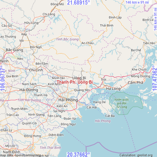
Thành Phố Uông Bí GPS coordinates[2]
21° 2' 3.588" North, 106° 46' 13.764" East
| Map corner | latitude | longitude |
|---|---|---|
| Upper-left | 21.68915°, | 106.06737° |
| Center: | 21.03433°, | 106.77049° |
| Lower-right: | 20.37662°, | 107.47362° |
| Map W x H: | 145.9×145.9 km | = 90.7×90.7mi |
| max Lat: | 23.27841° ⇑23.8% North |
| Thành Phố Uông Bí: | 21.03433° |
| min Lat: | ⇓76.2% South 8.65724° |
| min Long | Thành Phố U� | max Long |
| 102.4579° | 106.77049° | 112.72541° |
| W 71.3%⇐ | ⇒28.7% E |
Elevation
Elevation of Thành Phố Uông Bí is 11 m = 36 ft, and this is 118.5 m = 389 ft below average elevation for this country.
| Max E: |
1592 m = 5223 ft | 58.1% |
| Avg. | 129.5 m = 425 ft | |
| Thành Phố Uông Bí | 11 m = 36 ft | |
Min E: |
-1 m = -3 ft | 41.9% |
See also: Thành Phố Uông Bí elevation on elevation.city.
Geographical zone
Thành Phố Uông Bí is located in North Torrid zone (between Equator and Tropic of Cancer). Distance of this Northern Tropic circle is 267.1 km =166 mi to North.| Distance of | km | miles | from Thành Phố Uông Bí |
|---|---|---|---|
| North Pole | 7668.3 | 4764.9 | to North |
| Arctic Circle | 5062.4 | 3145.6 | to North |
| Tropic Cancer | 267.1 | 166 | to North |
| Equator | 2338.8 | 1453.3 | to South |


Nearby cities:
15 places around Thành Phố Uông Bí: (largest is in red/bold)
• An Châu
34.4 km =21.4 mi,  13°
13°
• An Dương
25 km =15.5 mi,  220°
220°
• An Lão
32.4 km =20.1 mi, 223°
• Chũ
43.3 km =26.9 mi,  330°
330°
• Cát Bà
44.7 km =27.8 mi,  139°
139°
• Haiphong
20.9 km =13 mi,  205°
205°
• Hạ Long
32.8 km =20.4 mi,  106°
106°
• Kinh Môn
22.9 km =14.2 mi,  257°
257°
• Núi Đèo
16.5 km =10.3 mi, 217°
• Núi Đối
33.2 km =20.6 mi,  198°
198°
• Phú Thái
28.2 km =17.5 mi,  253°
253°
• Quảng Yên
10.8 km =6.7 mi,  161°
161°
• Thanh Hà
38.8 km =24.1 mi, 247°
• Tiên Lãng
41.1 km =25.5 mi, 213°
• Trới
22.9 km =14.2 mi,  90°
90°
Sources, notices
• [Note1] Compared only with cities in Vietnam existing in our database
• [Src1] Map data: © OpenStreetMap contributors (CC-BY-SA)
• [Src2] Other city data from geonames.org with taken over terms of usage.
• [Src3] Geographical zone / Annual Mean Temperature by Robert A. Rohde @ Wikipedia
