Ân Thi geodata
Ân Thi (Hưng Yên) is a seat of a second-order administrative division; located in Vietnam in Asia/Ho_Chi_Minh (GMT+7) time zone. In our database, there are 94 cities with bigger population. Compared to other cities in Vietnam, 69.2% of cities are located further ↓South; 51.1% of cities are located further →East and 87.1% of cities have higher elevation than Ân Thi. Note1


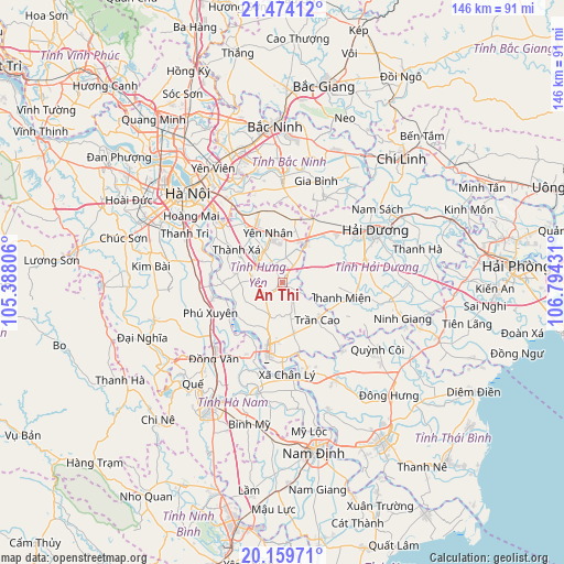
Ân Thi GPS coordinates[2]
20° 49' 6.06" North, 106° 5' 28.248" East
| Map corner | latitude | longitude |
|---|---|---|
| Upper-left | 21.47412°, | 105.38806° |
| Center: | 20.81835°, | 106.09118° |
| Lower-right: | 20.15971°, | 106.79431° |
| Map W x H: | 146.1×146.2 km | = 90.8×90.8mi |
| max Lat: | 23.27841° ⇑30.8% North |
| Ân Thi: | 20.81835° |
| min Lat: | ⇓69.2% South 8.65724° |
| min Long | Ân Thi | max Long |
| 102.4579° | 106.09118° | 112.72541° |
| W 48.9%⇐ | ⇒51.1% E |
Elevation
Elevation of Ân Thi is 5 m = 16 ft, and this is 124.5 m = 408 ft below average elevation for this country.
| Max E: |
1592 m = 5223 ft | 87.1% |
| Avg. | 129.5 m = 425 ft | |
| Ân Thi | 5 m = 16 ft | |
Min E: |
-1 m = -3 ft | 12.9% |
See also: Vietnam elevation on elevation.city.
Geographical zone
Ân Thi is located in North Torrid zone (between Equator and Tropic of Cancer). Distance of this Northern Tropic circle is 291.1 km =180.9 mi to North.| Distance of | km | miles | from Ân Thi |
|---|---|---|---|
| North Pole | 7692.3 | 4779.8 | to North |
| Arctic Circle | 5086.4 | 3160.5 | to North |
| Tropic Cancer | 291.1 | 180.9 | to North |
| Equator | 2314.8 | 1438.3 | to South |


Nearby cities:
15 places around Ân Thi: (largest is in red/bold)
• Bẩn Yên Nhân
13.6 km =8.5 mi,  344°
344°
• Gia Lộc
22.4 km =13.9 mi,  75°
75°
• Hòa Mạc
22.3 km =13.9 mi,  208°
208°
• Hưng Yên
19.6 km =12.2 mi,  192°
192°
• Khoái Châu
12 km =7.5 mi,  281°
281°
• Kẻ Sặt
11.8 km =7.3 mi,  29°
29°
• Lai Cách
20.6 km =12.8 mi,  51°
51°
• Lương Bằng
9.3 km =5.8 mi,  200°
200°
• Như Quỳnh
21.3 km =13.2 mi,  328°
328°
• Phú Xuyên
20.2 km =12.6 mi,  246°
246°
• Thanh Miện
16.5 km =10.3 mi,  102°
102°
• Trần Cao
13.5 km =8.4 mi,  137°
137°
• Văn Giang
21.6 km =13.4 mi,  309°
309°
• Vương
13.3 km =8.3 mi,  168°
168°
• Yên Mỹ
9.4 km =5.8 mi,  322°
322°
Sources, notices
• [Note1] Compared only with cities in Vietnam existing in our database
• [Src1] Map data: © OpenStreetMap contributors (CC-BY-SA)
• [Src2] Other city data from geonames.org with taken over terms of usage.
• [Src3] Geographical zone / Annual Mean Temperature by Robert A. Rohde @ Wikipedia
