Hòa Mạc geodata
Hòa Mạc (Hà Nam) is a seat of a second-order administrative division; located in Vietnam in Asia/Ho_Chi_Minh (GMT+7) time zone. In our database, there are 94 cities with bigger population. Compared to other cities in Vietnam, 66.4% of cities are located further ↓South; 55.3% of cities are located further →East and 65.4% of cities have higher elevation than Hòa Mạc. Note1


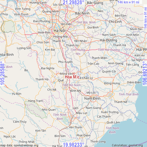
Hòa Mạc GPS coordinates[2]
20° 38' 30.228" North, 105° 59' 20.4" East
| Map corner | latitude | longitude |
|---|---|---|
| Upper-left | 21.29828°, | 105.28588° |
| Center: | 20.64173°, | 105.989° |
| Lower-right: | 19.98233°, | 106.69213° |
| Map W x H: | 146.3×146.3 km | = 90.9×90.9mi |
| max Lat: | 23.27841° ⇑33.6% North |
| Hòa Mạc: | 20.64173° |
| min Lat: | ⇓66.4% South 8.65724° |
| min Long | Hòa Mạc | max Long |
| 102.4579° | 105.989° | 112.72541° |
| W 44.7%⇐ | ⇒55.3% E |
Elevation
Elevation of Hòa Mạc is 9 m = 30 ft, and this is 120.5 m = 395 ft below average elevation for this country.
| Max E: |
1592 m = 5223 ft | 65.4% |
| Avg. | 129.5 m = 425 ft | |
| Hòa Mạc | 9 m = 30 ft | |
Min E: |
-1 m = -3 ft | 34.6% |
See also: Vietnam elevation on elevation.city.
Geographical zone
Hòa Mạc is located in North Torrid zone (between Equator and Tropic of Cancer). Distance of this Northern Tropic circle is 310.8 km =193.1 mi to North.| Distance of | km | miles | from Hòa Mạc |
|---|---|---|---|
| North Pole | 7711.9 | 4792 | to North |
| Arctic Circle | 5106 | 3172.7 | to North |
| Tropic Cancer | 310.8 | 193.1 | to North |
| Equator | 2295.1 | 1426.1 | to South |


Nearby cities:
15 places around Hòa Mạc: (largest is in red/bold)
• Bình Mỹ
16.9 km =10.5 mi,  172°
172°
• Hưng Hà
25.2 km =15.7 mi,  103°
103°
• Hưng Yên
6.5 km =4 mi,  85°
85°
• Khoái Châu
22 km =13.7 mi,  356°
356°
• Lương Bằng
13.2 km =8.2 mi,  34°
34°
• Mỹ Lộc
25.2 km =15.7 mi,  152°
152°
• Phú Xuyên
13.9 km =8.6 mi,  325°
325°
• Phủ Lý
13.4 km =8.3 mi,  216°
216°
• Quế
13.9 km =8.6 mi,  240°
240°
• Thanh Lưu
19 km =11.8 mi,  191°
191°
• Trần Cao
22.1 km =13.7 mi,  63°
63°
• Vân Đình
24.8 km =15.4 mi,  294°
294°
• Vĩnh Trụ
9.9 km =6.2 mi,  155°
155°
• Vương
14.9 km =9.3 mi, 63°
• Ân Thi
22.3 km =13.9 mi, 28°
Sources, notices
• [Note1] Compared only with cities in Vietnam existing in our database
• [Src1] Map data: © OpenStreetMap contributors (CC-BY-SA)
• [Src2] Other city data from geonames.org with taken over terms of usage.
• [Src3] Geographical zone / Annual Mean Temperature by Robert A. Rohde @ Wikipedia
