Duy Xuyên geodata
Duy Xuyên (Quảng Nam) is a seat of a second-order administrative division; located in Vietnam in Asia/Ho_Chi_Minh (GMT+7) time zone. In our database, there are 94 cities with bigger population. Compared to other cities in Vietnam, 53.7% of cities are located further ↑North; 88.9% of cities are located further ←West and 61.7% of cities have higher elevation than Duy Xuyên. Note1


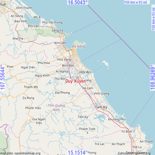
Duy Xuyên GPS coordinates[2]
15° 49' 44.328" North, 108° 15' 34.416" East
| Map corner | latitude | longitude |
|---|---|---|
| Upper-left | 16.5043°, | 107.55644° |
| Center: | 15.82898°, | 108.25956° |
| Lower-right: | 15.1514°, | 108.96269° |
| Map W x H: | 150.4×150.4 km | = 93.5×93.5mi |
| max Lat: | 23.27841° ⇑53.7% North |
| Duy Xuyên: | 15.82898° |
| min Lat: | ⇓46.3% South 8.65724° |
| min Long | Duy Xuyên | max Long |
| 102.4579° | 108.25956° | 112.72541° |
| W 88.9%⇐ | ⇒11.1% E |
Elevation
Elevation of Duy Xuyên is 10 m = 33 ft, and this is 119.5 m = 392 ft below average elevation for this country.
| Max E: |
1592 m = 5223 ft | 61.7% |
| Avg. | 129.5 m = 425 ft | |
| Duy Xuyên | 10 m = 33 ft | |
Min E: |
-1 m = -3 ft | 38.3% |
See also: Vietnam elevation on elevation.city.
Geographical zone
Duy Xuyên is located in North Torrid zone (between Equator and Tropic of Cancer). Distance of this Northern Tropic circle is 845.9 km =525.6 mi to North.| Distance of | km | miles | from Duy Xuyên |
|---|---|---|---|
| North Pole | 8247 | 5124.4 | to North |
| Arctic Circle | 5641.2 | 3505.3 | to North |
| Tropic Cancer | 845.9 | 525.6 | to North |
| Equator | 1760 | 1093.6 | to South |


Nearby cities:
15 places around Duy Xuyên: (largest is in red/bold)
• Cẩm Lệ
21.8 km =13.5 mi,  344°
344°
• Da Nang
26.9 km =16.7 mi,  351°
351°
• Doug An
31.5 km =19.6 mi,  209°
209°
• Hà Lam
14 km =8.7 mi,  135°
135°
• Hòa Vang
21.9 km =13.6 mi,  323°
323°
• Hội An
9.8 km =6.1 mi,  55°
55°
• Liên Chiểu
29.2 km =18.1 mi, 338°
• Ngũ Hành Sơn
20.8 km =12.9 mi,  358°
358°
• Phú Ninh
34.6 km =21.5 mi,  151°
151°
• Quang Nam
6.6 km =4.1 mi, 355°
• Quế Sơn
17.8 km =11.1 mi,  193°
193°
• Sơn Trà
25.9 km =16.1 mi, 353°
• Tam Kỳ
36.5 km =22.7 mi, 141°
• Thanh Khê
27.8 km =17.3 mi, 344°
• Đại Lộc
16 km =9.9 mi,  291°
291°
Sources, notices
• [Note1] Compared only with cities in Vietnam existing in our database
• [Src1] Map data: © OpenStreetMap contributors (CC-BY-SA)
• [Src2] Other city data from geonames.org with taken over terms of usage.
• [Src3] Geographical zone / Annual Mean Temperature by Robert A. Rohde @ Wikipedia
