Côn Sơn geodata
Côn Sơn (Bà Rịa-Vũng Tàu) is a populated place; located in Vietnam in Asia/Ho_Chi_Minh (GMT+7) time zone. With population of 1,500 people, there are 92 cities with bigger population in this country. Compared to other cities in Vietnam, 99.8% of cities are located further ↑North; 65.9% of cities are located further ←West and 87.1% of cities have higher elevation than Côn Sơn. Note1


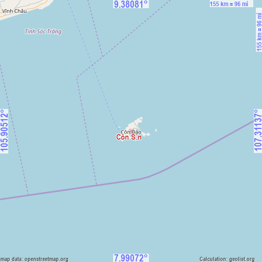
Côn Sơn GPS coordinates[2]
8° 41' 11.076" North, 106° 36' 29.664" East
| Map corner | latitude | longitude |
|---|---|---|
| Upper-left | 9.38081°, | 105.90512° |
| Center: | 8.68641°, | 106.60824° |
| Lower-right: | 7.99072°, | 107.31137° |
| Map W x H: | 154.6×154.6 km | = 96.1×96.1mi |
| max Lat: | 23.27841° ⇑99.8% North |
| Côn Sơn: | 8.68641° |
| min Lat: | ⇓0.2% South 8.65724° |
| min Long | Côn Sơn | max Long |
| 102.4579° | 106.60824° | 112.72541° |
| W 65.9%⇐ | ⇒34.1% E |
Elevation
Elevation of Côn Sơn is 5 m = 16 ft, and this is 124.5 m = 408 ft below average elevation for this country.
| Max E: |
1592 m = 5223 ft | 87.1% |
| Avg. | 129.5 m = 425 ft | |
| Côn Sơn | 5 m = 16 ft | |
Min E: |
-1 m = -3 ft | 12.9% |
See also: Vietnam elevation on elevation.city.
Geographical zone
Côn Sơn is located in North Torrid zone (between Equator and Tropic of Cancer). Distance of Equator is 965.8 km =600.1 mi to South.| Distance of | km | miles | from Côn Sơn |
|---|---|---|---|
| North Pole | 9041.2 | 5617.9 | to North |
| Arctic Circle | 6435.3 | 3998.7 | to North |
| Tropic Cancer | 1640.1 | 1019.1 | to North |
| Equator | 965.8 | 600.1 | to South |


Nearby cities:
15 places around Côn Sơn: (largest is in red/bold)
• Bạc Liêu
118 km =73.3 mi,  304°
304°
• Châu Thành
134.6 km =83.6 mi,  347°
347°
• Châu Thành
136.8 km =85 mi,  325°
325°
• Cù Lao Dung
120.8 km =75.1 mi,  335°
335°
• Duyên Hải
106.2 km =66 mi, 353°
• Huỳnh Hữu Nghĩa
137 km =85.1 mi,  320°
320°
• Long Phú
115.9 km =72 mi, 332°
• Mỹ Xuyên
118.5 km =73.6 mi, 325°
• Phú Lộc
126 km =78.3 mi,  310°
310°
• Sóc Trăng
123.3 km =76.6 mi, 325°
• Thị Trấn Gành Hào
136 km =84.5 mi,  286°
286°
• Thị Trấn Hòa Bình
126.4 km =78.5 mi, 301°
• Tiểu Cần
133.2 km =82.8 mi, 339°
• Trà Cú
118.8 km =73.8 mi, 341°
• Vĩnh Châu
98.9 km =61.5 mi, 315°
Sources, notices
• [Note1] Compared only with cities in Vietnam existing in our database
• [Src1] Map data: © OpenStreetMap contributors (CC-BY-SA)
• [Src2] Other city data from geonames.org with taken over terms of usage.
• [Src3] Geographical zone / Annual Mean Temperature by Robert A. Rohde @ Wikipedia
