Lotofagā geodata
Lotofagā (Atua) is a populated place; located in Samoa in Pacific/Apia (GMT+13) time zone. With population of 1,126 people, there are 18 cities with bigger population in this country. Compared to other cities in Samoa, 83.6% of cities are located further ↑North; 54.1% of cities are located further ←West and 57.4% of cities have higher elevation than Lotofagā. Note1


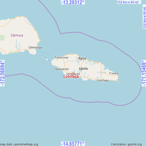
Lotofagā GPS coordinates[2]
13° 58' 35.148" South, 171° 51' 28.116" West
| Map corner | latitude | longitude |
|---|---|---|
| Upper-left | -13.29312°, | -172.56094° |
| Center: | -13.97643°, | -171.85781° |
| Lower-right: | -14.65771°, | -171.15469° |
| Map W x H: | 151.7×151.7 km | = 94.3×94.3mi |
| max Lat: | -13.44894° ⇑83.6% North |
| Lotofagā: | -13.97643° |
| min Lat: | ⇓16.4% South -14.04454° |
| min Long | Lotofagā | max Long |
| -172.69436° | -171.85781° | -171.42559° |
| W 54.1%⇐ | ⇒45.9% E |
Elevation
Elevation of Lotofagā is 12 m = 39 ft, and this is 11.9 m = 39 ft below average elevation for this country.
| Max E: |
252 m = 827 ft | 57.4% |
| Avg. | 23.9 m = 78 ft | |
| Lotofagā | 12 m = 39 ft | |
Min E: |
7 m = 23 ft | 42.6% |
See also: Samoa elevation on elevation.city.
Geographical zone
Lotofagā is located in South Torrid zone (between Equator and Tropic of Capricorn). Distance of this Southern Tropic circle is 1051.9 km =653.6 mi to South.| Distance of | km | miles | from Lotofagā |
|---|---|---|---|
| Equator | 1554 | 965.6 | to North |
| Tropic Capricorn | 1051.9 | 653.6 | to South |
| Antarctic Circle | 5847.1 | 3633.2 | to South |
| South Pole | 8453 | 5252.4 | to South |


Nearby cities:
15 places around Lotofagā: (largest is in red/bold)
• Afega
19.9 km =12.4 mi,  1°
1°
• Apia
18.7 km =11.6 mi,  31°
31°
• Lepea
17.3 km =10.7 mi, 25°
• Letogo
20.1 km =12.5 mi,  46°
46°
• Levī
17.9 km =11.1 mi,  292°
292°
• Malie
19.6 km =12.2 mi, 3°
• Pata
19.1 km =11.9 mi, 292°
• Saleilua
18.2 km =11.3 mi,  108°
108°
• Salepou‘a‘e
19.6 km =12.2 mi,  348°
348°
• Siusega
15.4 km =9.6 mi,  17°
17°
• Toamua
19.4 km =12.1 mi,  14°
14°
• Tufulele
20.1 km =12.5 mi,  341°
341°
• Vaigaga
18.3 km =11.4 mi, 21°
• Vailima
16.3 km =10.1 mi,  39°
39°
• Vaiusu
18 km =11.2 mi, 22°
Sources, notices
• [Note1] Compared only with cities in Samoa existing in our database
• [Src1] Map data: © OpenStreetMap contributors (CC-BY-SA)
• [Src2] Other city data from geonames.org with taken over terms of usage.
• [Src3] Geographical zone / Annual Mean Temperature by Robert A. Rohde @ Wikipedia
