Kačanik geodata
Kačanik (Ferizaj) is a seat of a second-order administrative division; located in Kosovo in Europe/Belgrade (GMT+2) time zone. With population of 9,800 people, there are 23 cities with bigger population in this country. Compared to other cities in Kosovo, 95.4% of cities are located further ↑North; 86.2% of cities are located further ←West and 73.8% of cities have higher elevation than Kačanik. Note1


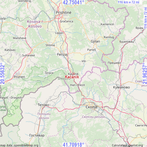
Kačanik GPS coordinates[2]
42° 13' 54.984" North, 21° 15' 33.984" East
| Map corner | latitude | longitude |
|---|---|---|
| Upper-left | 42.75041°, | 20.55632° |
| Center: | 42.23194°, | 21.25944° |
| Lower-right: | 41.70918°, | 21.96257° |
| Map W x H: | 115.8×115.8 km | = 72×72mi |
| max Lat: | 43.10389° ⇑95.4% North |
| Kačanik: | 42.23194° |
| min Lat: | ⇓4.6% South 42.0265° |
| min Long | Kačanik | max Long |
| 20.27722° | 21.25944° | 21.59889° |
| W 86.2%⇐ | ⇒13.8% E |
Elevation
Elevation of Kačanik is 487 m = 1598 ft, and this is 57.6 m = 189 ft below average elevation for this country.
| Max E: |
1062 m = 3484 ft | 73.8% |
| Avg. | 544.6 m = 1787 ft | |
| Kačanik | 487 m = 1598 ft | |
Min E: |
333 m = 1093 ft | 26.2% |
See also: Kosovo elevation on elevation.city.
Geographical zone
Kačanik is located in North temperate zone (between Tropic of Cancer and the Arctic Circle). Distance of this Northern Tropic circle is 2089.8 km =1298.5 mi to South.| Distance of | km | miles | from Kačanik |
|---|---|---|---|
| North Pole | 5311.3 | 3300.3 | to North |
| Arctic Circle | 2705.4 | 1681.1 | to North |
| Tropic Cancer | 2089.8 | 1298.5 | to South |
| Equator | 4695.8 | 2917.8 | to South |


Nearby cities:
15 places around Kačanik: (largest is in red/bold)
• Budakovo
30.7 km =19.1 mi,  296°
296°
• Ferizaj
17.6 km =10.9 mi,  330°
330°
• Gjilan
30.7 km =19.1 mi,  34°
34°
• Gjinoc
37.5 km =23.3 mi,  284°
284°
• Glanica
38.8 km =24.1 mi,  335°
335°
• Hani i Elezit
9.6 km =6 mi,  161°
161°
• Klokot
18.2 km =11.3 mi, 31°
• Lipljan
34 km =21.1 mi, 341°
• Partesh
23.7 km =14.7 mi,  37°
37°
• Pasjane
27.5 km =17.1 mi, 44°
• Peqan
39.7 km =24.7 mi, 295°
• Shtime
28.7 km =17.8 mi,  321°
321°
• Suva Reka
38.4 km =23.9 mi,  291°
291°
• Vitina
12.8 km =8 mi, 39°
• Štrpce
19.1 km =11.9 mi,  272°
272°
Sources, notices
• [Note1] Compared only with cities in Kosovo existing in our database
• [Src1] Map data: © OpenStreetMap contributors (CC-BY-SA)
• [Src2] Other city data from geonames.org with taken over terms of usage.
• [Src3] Geographical zone / Annual Mean Temperature by Robert A. Rohde @ Wikipedia
