Koungou geodata
Koungou is a seat of a first-order administrative division; located in Mayotte in Indian/Mayotte (GMT+3) time zone. With population of 18,118 people, there is 1 city with bigger population in this country. Compared to other cities in Mayotte, 81.3% of cities are located further ↓South; 81.3% of cities are located further ←West and 56.3% of cities have lower elevation than Koungou. Note1


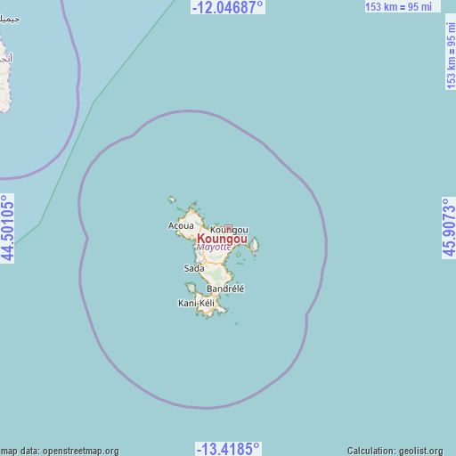
Koungou GPS coordinates[2]
12° 44' 0.996" South, 45° 12' 15.012" East
| Map corner | latitude | longitude |
|---|---|---|
| Upper-left | -12.04687°, | 44.50105° |
| Center: | -12.73361°, | 45.20417° |
| Lower-right: | -13.4185°, | 45.9073° |
| Map W x H: | 152.5×152.5 km | = 94.8×94.8mi |
| max Lat: | -12.69982° ⇑18.7% North |
| Koungou: | -12.73361° |
| min Lat: | ⇓81.3% South -12.95361° |
| min Long | Koungou | max Long |
| 45.05819° | 45.20417° | 45.27938° |
| W 81.3%⇐ | ⇒18.7% E |
Elevation
Elevation of Koungou is 40 m = 131 ft, and this is 3.9 m = 13 ft below average elevation for this country.
| Max E: |
109 m = 358 ft | 43.7% |
| Avg. | 43.9 m = 144 ft | |
| Koungou | 40 m = 131 ft | |
Min E: |
10 m = 33 ft | 56.3% |
See also: Mayotte elevation on elevation.city.
Geographical zone
Koungou is located in South Torrid zone (between Equator and Tropic of Capricorn). Distance of this Southern Tropic circle is 1190.1 km =739.5 mi to South.| Distance of | km | miles | from Koungou |
|---|---|---|---|
| Equator | 1415.8 | 879.7 | to North |
| Tropic Capricorn | 1190.1 | 739.5 | to South |
| Antarctic Circle | 5985.3 | 3719.1 | to South |
| South Pole | 8591.2 | 5338.3 | to South |


Nearby cities:
15 places around Koungou: (largest is in red/bold)
• Acoua
15.9 km =9.9 mi,  273°
273°
• Bandraboua
9.5 km =5.9 mi,  290°
290°
• Bandrélé
20 km =12.4 mi,  183°
183°
• Bouéni
23.4 km =14.5 mi,  216°
216°
• Chiconi
15 km =9.3 mi, 222°
• Chirongui
22.9 km =14.2 mi,  195°
195°
• Dembeni
12.4 km =7.7 mi,  189°
189°
• Dzaoudzi
8 km =5 mi,  134°
134°
• M'Tsangamouji
13.4 km =8.3 mi,  257°
257°
• Mamoudzou
6 km =3.7 mi,  153°
153°
• Mtsamboro
15.1 km =9.4 mi,  284°
284°
• Ouangani
14.6 km =9.1 mi,  210°
210°
• Pamandzi
10.8 km =6.7 mi, 130°
• Sada
17.1 km =10.6 mi, 220°
• Tsingoni
12.5 km =7.8 mi,  241°
241°
Sources, notices
• [Note1] Compared only with cities in Mayotte existing in our database
• [Src1] Map data: © OpenStreetMap contributors (CC-BY-SA)
• [Src2] Other city data from geonames.org with taken over terms of usage.
• [Src3] Geographical zone / Annual Mean Temperature by Robert A. Rohde @ Wikipedia
