Bandrélé geodata
Bandrélé (Bandrele) is a seat of a first-order administrative division; located in Mayotte in Indian/Mayotte (GMT+3) time zone. With population of 6,350 people, there are 11 cities with bigger population in this country. Compared to other cities in Mayotte, 87.5% of cities are located further ↑North; 75% of cities are located further ←West and 87.5% of cities have higher elevation than Bandrélé. Note1


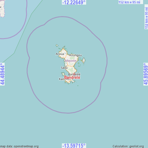
Bandrélé GPS coordinates[2]
12° 54' 45.936" South, 45° 11' 33.216" East
| Map corner | latitude | longitude |
|---|---|---|
| Upper-left | -12.22649°, | 44.48944° |
| Center: | -12.91276°, | 45.19256° |
| Lower-right: | -13.59715°, | 45.89569° |
| Map W x H: | 152.4×152.4 km | = 94.7×94.7mi |
| max Lat: | -12.69982° ⇑87.5% North |
| Bandrélé: | -12.91276° |
| min Lat: | ⇓12.5% South -12.95361° |
| min Long | Bandrélé | max Long |
| 45.05819° | 45.19256° | 45.27938° |
| W 75%⇐ | ⇒25% E |
Elevation
Elevation of Bandrélé is 14 m = 46 ft, and this is 29.9 m = 98 ft below average elevation for this country.
| Max E: |
109 m = 358 ft | 87.5% |
| Avg. | 43.9 m = 144 ft | |
| Bandrélé | 14 m = 46 ft | |
Min E: |
10 m = 33 ft | 12.5% |
See also: Mayotte elevation on elevation.city.
Geographical zone
Bandrélé is located in South Torrid zone (between Equator and Tropic of Capricorn). Distance of this Southern Tropic circle is 1170.2 km =727.1 mi to South.| Distance of | km | miles | from Bandrélé |
|---|---|---|---|
| Equator | 1435.8 | 892.2 | to North |
| Tropic Capricorn | 1170.2 | 727.1 | to South |
| Antarctic Circle | 5965.4 | 3706.7 | to South |
| South Pole | 8571.3 | 5326 | to South |


Nearby cities:
15 places around Bandrélé: (largest is in red/bold)
• Acoua
25.6 km =15.9 mi,  325°
325°
• Bandraboua
24.4 km =15.2 mi,  341°
341°
• Bouéni
12.7 km =7.9 mi,  275°
275°
• Chiconi
12.5 km =7.8 mi,  314°
314°
• Chirongui
5.2 km =3.2 mi,  246°
246°
• Dembeni
7.7 km =4.8 mi,  353°
353°
• Dzaoudzi
16 km =9.9 mi,  25°
25°
• Kani Kéli
10.7 km =6.6 mi,  244°
244°
• Koungou
20 km =12.4 mi,  3°
3°
• M'Tsangamouji
20.7 km =12.9 mi, 325°
• Mamoudzou
15 km =9.3 mi,  15°
15°
• Ouangani
9.6 km =6 mi,  320°
320°
• Pamandzi
16 km =9.9 mi,  36°
36°
• Sada
12 km =7.5 mi, 305°
• Tsingoni
17 km =10.6 mi, 325°
Sources, notices
• [Note1] Compared only with cities in Mayotte existing in our database
• [Src1] Map data: © OpenStreetMap contributors (CC-BY-SA)
• [Src2] Other city data from geonames.org with taken over terms of usage.
• [Src3] Geographical zone / Annual Mean Temperature by Robert A. Rohde @ Wikipedia
