Eindhoven geodata
Eindhoven (North Brabant) is a populated place; located in Netherlands in Europe/Amsterdam (GMT+2) time zone. With population of 209,620 people, there are 4 cities with bigger population in this country. Compared to other cities in Netherlands, 84.4% of cities are located further ↑North; 57.6% of cities are located further →East and 81.4% of cities have lower elevation than Eindhoven. Note1


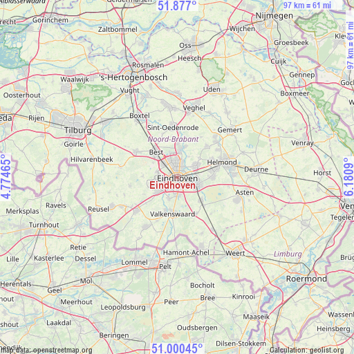
Eindhoven GPS coordinates[2]
51° 26' 26.988" North, 5° 28' 40.008" East
| Map corner | latitude | longitude |
|---|---|---|
| Upper-left | 51.877°, | 4.77465° |
| Center: | 51.44083°, | 5.47778° |
| Lower-right: | 51.00045°, | 6.1809° |
| Map W x H: | 97.5×97.5 km | = 60.6×60.6mi |
| max Lat: | 53.48025° ⇑84.4% North |
| Eindhoven: | 51.44083° |
| min Lat: | ⇓15.6% South 50.76917° |
| min Long | Eindhoven | max Long |
| 3.38611° | 5.47778° | 7.16528° |
| W 42.4%⇐ | ⇒57.6% E |
Elevation
Elevation of Eindhoven is 22 m = 72 ft, and this is 7 m = 23 ft above average elevation for this country.
| Max E: |
203 m = 666 ft | 18.6% |
| Eindhoven | 22 m 72 ft | |
| Avg. | 15 m = 49 ft | |
Min E: |
-6 m = -20 ft | 81.4% |
See also: Eindhoven elevation on elevation.city.
Geographical zone
Eindhoven is located in North temperate zone (between Tropic of Cancer and the Arctic Circle). Distance of this North polar circle is 1681.5 km =1044.8 mi to North.| Distance of | km | miles | from Eindhoven |
|---|---|---|---|
| North Pole | 4287.4 | 2664.1 | to North |
| Arctic Circle | 1681.5 | 1044.8 | to North |
| Tropic Cancer | 3113.8 | 1934.8 | to South |
| Equator | 5719.7 | 3554.1 | to South |


Nearby cities:
15 places around Eindhoven: (largest is in red/bold)
• 't Hofke
3 km =1.9 mi,  71°
71°
• Blaarthem
2.2 km =1.4 mi,  218°
218°
• De Doornakkers
2.2 km =1.4 mi,  97°
97°
• Eckart
3.8 km =2.4 mi,  17°
17°
• Grasrijk
4.3 km =2.7 mi,  267°
267°
• Jagershoef
3.7 km =2.3 mi,  348°
348°
• Lakerlopen
1.6 km =1 mi, 101°
• Lievendaal
3 km =1.9 mi, 272°
• Muschberg en Geestenberg
3.2 km =2 mi,  83°
83°
• Ooievaarsnest
4.1 km =2.5 mi,  228°
228°
• Tivoli
3.1 km =1.9 mi,  136°
136°
• Tongelre
3 km =1.9 mi, 72°
• Vaartbroek
4.5 km =2.8 mi, 18°
• Villapark
1.1 km =0.7 mi,  86°
86°
• Vlokhoven
2.9 km =1.8 mi,  7°
7°
Sources, notices
• [Note1] Compared only with cities in Netherlands existing in our database
• [Src1] Map data: © OpenStreetMap contributors (CC-BY-SA)
• [Src2] Other city data from geonames.org with taken over terms of usage.
• [Src3] Geographical zone / Annual Mean Temperature by Robert A. Rohde @ Wikipedia
