Kyoto geodata
Kyoto is a seat of a first-order administrative division; located in Japan in Asia/Tokyo (GMT+9) time zone. With population of 1,459,640 people, there are 6 cities with bigger population in this country. Compared to other cities in Japan, 57.9% of cities are located further ↑North; 63.5% of cities are located further →East and 62% of cities have lower elevation than Kyoto. Note1


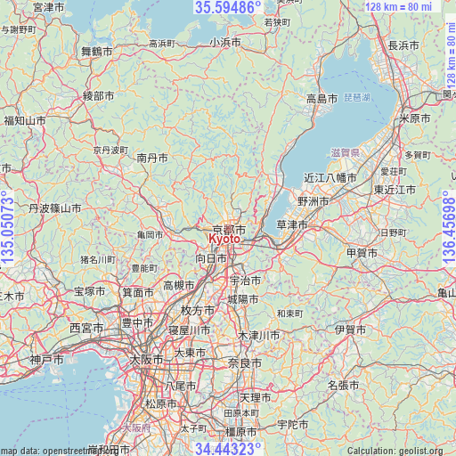
Kyoto GPS coordinates[2]
35° 1' 15.852" North, 135° 45' 13.86" East
| Map corner | latitude | longitude |
|---|---|---|
| Upper-left | 35.59486°, | 135.05073° |
| Center: | 35.02107°, | 135.75385° |
| Lower-right: | 34.44323°, | 136.45698° |
| Map W x H: | 128×128 km | = 79.5×79.5mi |
| max Lat: | 45.40944° ⇑57.9% North |
| Kyoto: | 35.02107° |
| min Lat: | ⇓42.1% South 24.34478° |
| min Long | Kyoto | max Long |
| 123° | 135.75385° | 145.575° |
| W 36.5%⇐ | ⇒63.5% E |
Elevation
Elevation of Kyoto is 50 m = 164 ft, and this is 34.6 m = 114 ft below average elevation for this country.
| Max E: |
1086 m = 3563 ft | 38% |
| Avg. | 84.6 m = 278 ft | |
| Kyoto | 50 m = 164 ft | |
Min E: |
-2 m = -7 ft | 62% |
See also: Kyoto elevation on elevation.city.
Geographical zone
Kyoto is located in North temperate zone (between Tropic of Cancer and the Arctic Circle). Distance of this Northern Tropic circle is 1288.1 km =800.4 mi to South.| Distance of | km | miles | from Kyoto |
|---|---|---|---|
| North Pole | 6113.1 | 3798.5 | to North |
| Arctic Circle | 3507.2 | 2179.3 | to North |
| Tropic Cancer | 1288.1 | 800.4 | to South |
| Equator | 3894 | 2419.6 | to South |


Nearby cities:
15 places around Kyoto: (largest is in red/bold)
• Arashiyama
7 km =4.3 mi,  264°
264°
• Jōyō
20.3 km =12.6 mi,  166°
166°
• Kameoka
15.7 km =9.8 mi, 261°
• Kamigyō-ku
1 km =0.6 mi,  15°
15°
• Kitahama
21.9 km =13.6 mi,  42°
42°
• Kusatsu
19.4 km =12.1 mi,  91°
91°
• Moriyama
21.5 km =13.4 mi,  76°
76°
• Mukō
7.7 km =4.8 mi,  216°
216°
• Nagaoka
11.5 km =7.1 mi,  209°
209°
• Rittō
22.4 km =13.9 mi, 88°
• Takatsuki
22.9 km =14.2 mi, 213°
• Tanabe
22.1 km =13.7 mi,  177°
177°
• Uji
15.2 km =9.4 mi,  162°
162°
• Yawata
17.4 km =10.8 mi,  195°
195°
• Ōtsu
10.5 km =6.5 mi,  102°
102°
In other languages:
- In Spanish: Kioto
- In France: Kyōto
- In German: Kyōto
- In Russian: Киото
- In Chinese: 京都, 京都市
Sources, notices
• [Note1] Compared only with cities in Japan existing in our database
• [Src1] Map data: © OpenStreetMap contributors (CC-BY-SA)
• [Src2] Other city data from geonames.org with taken over terms of usage.
• [Src3] Geographical zone / Annual Mean Temperature by Robert A. Rohde @ Wikipedia
