Vukatanë geodata
Vukatanë (Shkodër) is a populated place; located in Albania in Europe/Tirane (GMT+2) time zone. With population of 1,113 people, there are 67 cities with bigger population in this country. Compared to other cities in Albania, 90.1% of cities are located further ↓South; 92.1% of cities are located further →East and 93.2% of cities have higher elevation than Vukatanë. Note1


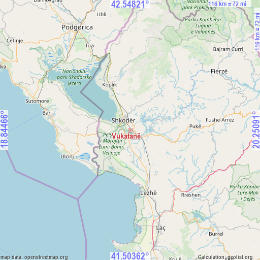
Vukatanë GPS coordinates[2]
42° 1' 41.016" North, 19° 32' 52.008" East
| Map corner | latitude | longitude |
|---|---|---|
| Upper-left | 42.54821°, | 18.84466° |
| Center: | 42.02806°, | 19.54778° |
| Lower-right: | 41.50362°, | 20.25091° |
| Map W x H: | 116.1×116.1 km | = 72.1×72.1mi |
| max Lat: | 42.45139° ⇑9.9% North |
| Vukatanë: | 42.02806° |
| min Lat: | ⇓90.1% South 39.65889° |
| min Long | Vukatanë | max Long |
| 19.40556° | 19.54778° | 20.99° |
| W 7.9%⇐ | ⇒92.1% E |
Elevation
Elevation of Vukatanë is 11 m = 36 ft, and this is 363.6 m = 1193 ft below average elevation for this country.
| Max E: |
1352 m = 4436 ft | 93.2% |
| Avg. | 374.6 m = 1229 ft | |
| Vukatanë | 11 m = 36 ft | |
Min E: |
-2 m = -7 ft | 6.8% |
See also: Albania elevation on elevation.city.
Geographical zone
Vukatanë is located in North temperate zone (between Tropic of Cancer and the Arctic Circle). Distance of this Northern Tropic circle is 2067.2 km =1284.5 mi to South.| Distance of | km | miles | from Vukatanë |
|---|---|---|---|
| North Pole | 5334 | 3314.4 | to North |
| Arctic Circle | 2728.1 | 1695.2 | to North |
| Tropic Cancer | 2067.2 | 1284.5 | to South |
| Equator | 4673.1 | 2903.7 | to South |


Nearby cities:
15 places around Vukatanë: (largest is in red/bold)
• Bërdica e Madhe
5.6 km =3.5 mi,  255°
255°
• Dajç
12 km =7.5 mi,  250°
250°
• Dajç
13.4 km =8.3 mi,  159°
159°
• Grudë-Fushë
15.5 km =9.6 mi,  344°
344°
• Gruemirë
14.8 km =9.2 mi,  350°
350°
• Guri i Zi
2.9 km =1.8 mi,  49°
49°
• Hajmel
11.2 km =7 mi,  138°
138°
• Kallmeti i Madh
23 km =14.3 mi,  149°
149°
• Koplik
22.6 km =14 mi, 335°
• Kuç
2.3 km =1.4 mi,  304°
304°
• Qerret
24.1 km =15 mi,  83°
83°
• Shkodër
5.3 km =3.3 mi,  326°
326°
• Shëngjin
24.1 km =15 mi,  170°
170°
• Vau i Dejës
6.7 km =4.2 mi,  107°
107°
• Velipojë
20.4 km =12.7 mi,  215°
215°
Sources, notices
• [Note1] Compared only with cities in Albania existing in our database
• [Src1] Map data: © OpenStreetMap contributors (CC-BY-SA)
• [Src2] Other city data from geonames.org with taken over terms of usage.
• [Src3] Geographical zone / Annual Mean Temperature by Robert A. Rohde @ Wikipedia
