Qerret geodata
Qerret (Shkodër) is a seat of a third-order administrative division; located in Albania in Europe/Tirane (GMT+2) time zone. In our database, there are 71 cities with bigger population. Compared to other cities in Albania, 92.1% of cities are located further ↓South; 62.5% of cities are located further →East and 73.8% of cities have lower elevation than Qerret. Note1


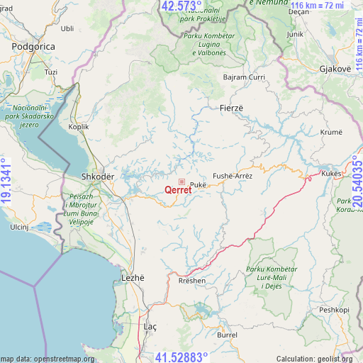
Qerret GPS coordinates[2]
42° 3' 11.016" North, 19° 50' 13.992" East
| Map corner | latitude | longitude |
|---|---|---|
| Upper-left | 42.573°, | 19.1341° |
| Center: | 42.05306°, | 19.83722° |
| Lower-right: | 41.52883°, | 20.54035° |
| Map W x H: | 116.1×116.1 km | = 72.1×72.1mi |
| max Lat: | 42.45139° ⇑7.9% North |
| Qerret: | 42.05306° |
| min Lat: | ⇓92.1% South 39.65889° |
| min Long | Qerret | max Long |
| 19.40556° | 19.83722° | 20.99° |
| W 37.5%⇐ | ⇒62.5% E |
Elevation
Elevation of Qerret is 652 m = 2139 ft, and this is 277.4 m = 910 ft above average elevation for this country.
| Max E: |
1352 m = 4436 ft | 26.2% |
| Qerret | 652 m 2139 ft | |
| Avg. | 374.6 m = 1229 ft | |
Min E: |
-2 m = -7 ft | 73.8% |
See also: Albania elevation on elevation.city.
Geographical zone
Qerret is located in North temperate zone (between Tropic of Cancer and the Arctic Circle). Distance of this Northern Tropic circle is 2069.9 km =1286.2 mi to South.| Distance of | km | miles | from Qerret |
|---|---|---|---|
| North Pole | 5331.2 | 3312.7 | to North |
| Arctic Circle | 2725.3 | 1693.4 | to North |
| Tropic Cancer | 2069.9 | 1286.2 | to South |
| Equator | 4675.9 | 2905.5 | to South |


Nearby cities:
15 places around Qerret: (largest is in red/bold)
• Bushat
9 km =5.6 mi,  34°
34°
• Fushë-Arrëz
14.8 km =9.2 mi,  86°
86°
• Gjegjan
19.3 km =12 mi,  131°
131°
• Guri i Zi
21.7 km =13.5 mi,  267°
267°
• Hajmel
19.9 km =12.4 mi,  235°
235°
• Iballë
20.2 km =12.6 mi,  42°
42°
• Kaçinar
18.5 km =11.5 mi,  164°
164°
• Nicaj-Shosh
22.3 km =13.9 mi,  342°
342°
• Pukë
5.2 km =3.2 mi,  100°
100°
• Qafëmal
21.4 km =13.3 mi,  77°
77°
• Qelëz
6.3 km =3.9 mi,  49°
49°
• Rrapë
11.1 km =6.9 mi, 94°
• Ungrej
20.1 km =12.5 mi,  190°
190°
• Vau i Dejës
18.2 km =11.3 mi,  254°
254°
• Vukatanë
24.1 km =15 mi,  263°
263°
Sources, notices
• [Note1] Compared only with cities in Albania existing in our database
• [Src1] Map data: © OpenStreetMap contributors (CC-BY-SA)
• [Src2] Other city data from geonames.org with taken over terms of usage.
• [Src3] Geographical zone / Annual Mean Temperature by Robert A. Rohde @ Wikipedia
