Grudë-Fushë geodata
Grudë-Fushë (Shkodër) is a seat of a third-order administrative division; located in Albania in Europe/Tirane (GMT+2) time zone. In our database, there are 71 cities with bigger population. Compared to other cities in Albania, 95.5% of cities are located further ↓South; 96.3% of cities are located further →East and 71.8% of cities have higher elevation than Grudë-Fushë. Note1


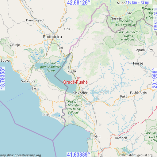
Grudë-Fushë GPS coordinates[2]
42° 9' 43.992" North, 19° 29' 48.012" East
| Map corner | latitude | longitude |
|---|---|---|
| Upper-left | 42.68126°, | 18.79355° |
| Center: | 42.16222°, | 19.49667° |
| Lower-right: | 41.63889°, | 20.1998° |
| Map W x H: | 115.9×115.9 km | = 72×72mi |
| max Lat: | 42.45139° ⇑4.5% North |
| Grudë-Fushë: | 42.16222° |
| min Lat: | ⇓95.5% South 39.65889° |
| min Long | Grudë-Fushë | max Long |
| 19.40556° | 19.49667° | 20.99° |
| W 3.7%⇐ | ⇒96.3% E |
Elevation
Elevation of Grudë-Fushë is 66 m = 217 ft, and this is 308.6 m = 1012 ft below average elevation for this country.
| Max E: |
1352 m = 4436 ft | 71.8% |
| Avg. | 374.6 m = 1229 ft | |
| Grudë-Fushë | 66 m = 217 ft | |
Min E: |
-2 m = -7 ft | 28.2% |
See also: Albania elevation on elevation.city.
Geographical zone
Grudë-Fushë is located in North temperate zone (between Tropic of Cancer and the Arctic Circle). Distance of this Northern Tropic circle is 2082.1 km =1293.8 mi to South.| Distance of | km | miles | from Grudë-Fushë |
|---|---|---|---|
| North Pole | 5319.1 | 3305.1 | to North |
| Arctic Circle | 2713.2 | 1685.9 | to North |
| Tropic Cancer | 2082.1 | 1293.8 | to South |
| Equator | 4688 | 2913 | to South |


Nearby cities:
15 places around Grudë-Fushë: (largest is in red/bold)
• Bërdica e Madhe
16.4 km =10.2 mi,  184°
184°
• Dajç
20.3 km =12.6 mi,  200°
200°
• Dajç
28.8 km =17.9 mi,  162°
162°
• Gruemirë
1.9 km =1.2 mi,  100°
100°
• Guri i Zi
14.5 km =9 mi,  153°
153°
• Hajmel
26 km =16.2 mi, 153°
• Hot
22.6 km =14 mi,  348°
348°
• Kastrat
21.2 km =13.2 mi,  358°
358°
• Koplik
7.6 km =4.7 mi,  319°
319°
• Kuç
13.8 km =8.6 mi,  170°
170°
• Nicaj-Shalë
29.6 km =18.4 mi,  58°
58°
• Nicaj-Shosh
23.4 km =14.5 mi,  66°
66°
• Shkodër
10.5 km =6.5 mi, 172°
• Vau i Dejës
20 km =12.4 mi, 148°
• Vukatanë
15.5 km =9.6 mi, 164°
Sources, notices
• [Note1] Compared only with cities in Albania existing in our database
• [Src1] Map data: © OpenStreetMap contributors (CC-BY-SA)
• [Src2] Other city data from geonames.org with taken over terms of usage.
• [Src3] Geographical zone / Annual Mean Temperature by Robert A. Rohde @ Wikipedia
