Dajç geodata
Dajç (Shkodër) is a seat of a third-order administrative division; located in Albania in Europe/Tirane (GMT+2) time zone. In our database, there are 71 cities with bigger population. Compared to other cities in Albania, 88.7% of cities are located further ↓South; 99.7% of cities are located further →East and 95.2% of cities have higher elevation than Dajç. Note1


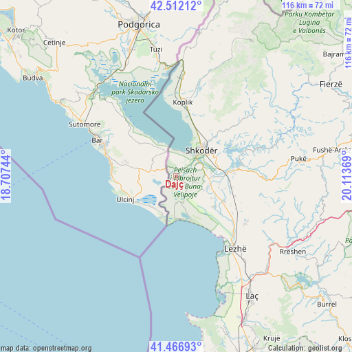
Dajç GPS coordinates[2]
41° 59' 30.012" North, 19° 24' 38.016" East
| Map corner | latitude | longitude |
|---|---|---|
| Upper-left | 42.51212°, | 18.70744° |
| Center: | 41.99167°, | 19.41056° |
| Lower-right: | 41.46693°, | 20.11369° |
| Map W x H: | 116.2×116.2 km | = 72.2×72.2mi |
| max Lat: | 42.45139° ⇑11.3% North |
| Dajç: | 41.99167° |
| min Lat: | ⇓88.7% South 39.65889° |
| min Long | Dajç | max Long |
| 19.40556° | 19.41056° | 20.99° |
| W 0.3%⇐ | ⇒99.7% E |
Elevation
Elevation of Dajç is 8 m = 26 ft, and this is 366.6 m = 1203 ft below average elevation for this country.
| Max E: |
1352 m = 4436 ft | 95.2% |
| Avg. | 374.6 m = 1229 ft | |
| Dajç | 8 m = 26 ft | |
Min E: |
-2 m = -7 ft | 4.8% |
See also: Albania elevation on elevation.city.
Geographical zone
Dajç is located in North temperate zone (between Tropic of Cancer and the Arctic Circle). Distance of this Northern Tropic circle is 2063.1 km =1282 mi to South.| Distance of | km | miles | from Dajç |
|---|---|---|---|
| North Pole | 5338 | 3316.9 | to North |
| Arctic Circle | 2732.1 | 1697.6 | to North |
| Tropic Cancer | 2063.1 | 1282 | to South |
| Equator | 4669 | 2901.2 | to South |


Nearby cities:
15 places around Dajç: (largest is in red/bold)
• Balldreni i Ri
27 km =16.8 mi,  135°
135°
• Bërdica e Madhe
6.4 km =4 mi,  65°
65°
• Dajç
18.1 km =11.2 mi,  117°
117°
• Grudë-Fushë
20.3 km =12.6 mi,  20°
20°
• Gruemirë
20.7 km =12.9 mi,  25°
25°
• Guri i Zi
14.8 km =9.2 mi, 66°
• Hajmel
19.3 km =12 mi,  102°
102°
• Kallmeti i Madh
27.8 km =17.3 mi, 124°
• Koplik
24.8 km =15.4 mi,  4°
4°
• Kuç
10.9 km =6.8 mi,  60°
60°
• Shkodër
12 km =7.5 mi,  44°
44°
• Shëngjin
24.9 km =15.5 mi, 142°
• Vau i Dejës
17.8 km =11.1 mi,  83°
83°
• Velipojë
12.6 km =7.8 mi,  181°
181°
• Vukatanë
12 km =7.5 mi, 70°
Sources, notices
• [Note1] Compared only with cities in Albania existing in our database
• [Src1] Map data: © OpenStreetMap contributors (CC-BY-SA)
• [Src2] Other city data from geonames.org with taken over terms of usage.
• [Src3] Geographical zone / Annual Mean Temperature by Robert A. Rohde @ Wikipedia
