Tërbuf geodata
Tërbuf (Fier) is a seat of a third-order administrative division; located in Albania in Europe/Tirane (GMT+2) time zone. In our database, there are 71 cities with bigger population. Compared to other cities in Albania, 50.4% of cities are located further ↑North; 85.6% of cities are located further →East and 96.9% of cities have higher elevation than Tërbuf. Note1


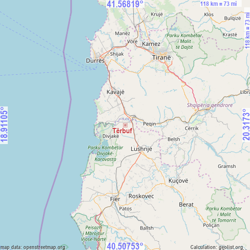
Tërbuf GPS coordinates[2]
41° 2' 24" North, 19° 36' 51.012" East
| Map corner | latitude | longitude |
|---|---|---|
| Upper-left | 41.56819°, | 18.91105° |
| Center: | 41.04°, | 19.61417° |
| Lower-right: | 40.50753°, | 20.3173° |
| Map W x H: | 117.9×117.9 km | = 73.3×73.3mi |
| max Lat: | 42.45139° ⇑50.4% North |
| Tërbuf: | 41.04° |
| min Lat: | ⇓49.6% South 39.65889° |
| min Long | Tërbuf | max Long |
| 19.40556° | 19.61417° | 20.99° |
| W 14.4%⇐ | ⇒85.6% E |
Elevation
Elevation of Tërbuf is 7 m = 23 ft, and this is 367.6 m = 1206 ft below average elevation for this country.
| Max E: |
1352 m = 4436 ft | 96.9% |
| Avg. | 374.6 m = 1229 ft | |
| Tërbuf | 7 m = 23 ft | |
Min E: |
-2 m = -7 ft | 3.1% |
See also: Albania elevation on elevation.city.
Geographical zone
Tërbuf is located in North temperate zone (between Tropic of Cancer and the Arctic Circle). Distance of this Northern Tropic circle is 1957.3 km =1216.2 mi to South.| Distance of | km | miles | from Tërbuf |
|---|---|---|---|
| North Pole | 5443.8 | 3382.6 | to North |
| Arctic Circle | 2838 | 1763.5 | to North |
| Tropic Cancer | 1957.3 | 1216.2 | to South |
| Equator | 4563.2 | 2835.4 | to South |


Nearby cities:
15 places around Tërbuf: (largest is in red/bold)
• Ballagat
13.6 km =8.5 mi,  111°
111°
• Divjakë
8.6 km =5.3 mi,  235°
235°
• Gjoçaj
9.3 km =5.8 mi,  99°
99°
• Golem
10 km =6.2 mi,  143°
143°
• Gosë e Madhe
5.7 km =3.5 mi,  8°
8°
• Grabjan
10.1 km =6.3 mi,  196°
196°
• Karinë
8.9 km =5.5 mi,  73°
73°
• Kryevidh
9.9 km =6.2 mi,  312°
312°
• Lekaj
8.3 km =5.2 mi,  357°
357°
• Lushnjë
13.3 km =8.3 mi,  145°
145°
• Luzi i Vogël
10.3 km =6.4 mi,  340°
340°
• Peqin
11.5 km =7.1 mi,  86°
86°
• Përparim
15.6 km =9.7 mi, 85°
• Rrogozhinë
5.9 km =3.7 mi,  46°
46°
• Sinaballaj
7.8 km =4.8 mi, 65°
Sources, notices
• [Note1] Compared only with cities in Albania existing in our database
• [Src1] Map data: © OpenStreetMap contributors (CC-BY-SA)
• [Src2] Other city data from geonames.org with taken over terms of usage.
• [Src3] Geographical zone / Annual Mean Temperature by Robert A. Rohde @ Wikipedia
