Lushnjë geodata
Lushnjë (Fier) is a seat of a second-order administrative division; located in Albania in Europe/Tirane (GMT+2) time zone. With population of 41,469 people, there are 11 cities with bigger population in this country. Compared to other cities in Albania, 56.3% of cities are located further ↑North; 75.2% of cities are located further →East and 86.5% of cities have higher elevation than Lushnjë. Note1


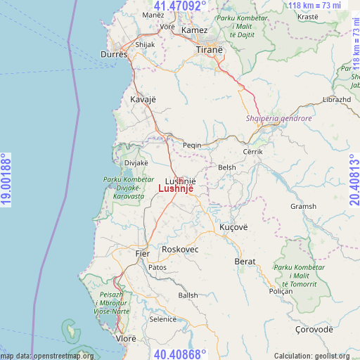
Lushnjë GPS coordinates[2]
40° 56' 30.984" North, 19° 42' 18" East
| Map corner | latitude | longitude |
|---|---|---|
| Upper-left | 41.47092°, | 19.00188° |
| Center: | 40.94194°, | 19.705° |
| Lower-right: | 40.40868°, | 20.40813° |
| Map W x H: | 118.1×118.1 km | = 73.4×73.4mi |
| max Lat: | 42.45139° ⇑56.3% North |
| Lushnjë: | 40.94194° |
| min Lat: | ⇓43.7% South 39.65889° |
| min Long | Lushnjë | max Long |
| 19.40556° | 19.705° | 20.99° |
| W 24.8%⇐ | ⇒75.2% E |
Elevation
Elevation of Lushnjë is 22 m = 72 ft, and this is 352.6 m = 1157 ft below average elevation for this country.
| Max E: |
1352 m = 4436 ft | 86.5% |
| Avg. | 374.6 m = 1229 ft | |
| Lushnjë | 22 m = 72 ft | |
Min E: |
-2 m = -7 ft | 13.5% |
See also: Lushnjë elevation on elevation.city.
Geographical zone
Lushnjë is located in North temperate zone (between Tropic of Cancer and the Arctic Circle). Distance of this Northern Tropic circle is 1946.4 km =1209.4 mi to South.| Distance of | km | miles | from Lushnjë |
|---|---|---|---|
| North Pole | 5454.7 | 3389.4 | to North |
| Arctic Circle | 2848.9 | 1770.2 | to North |
| Tropic Cancer | 1946.4 | 1209.4 | to South |
| Equator | 4552.3 | 2828.7 | to South |


Nearby cities:
15 places around Lushnjë: (largest is in red/bold)
• Allkaj
10.3 km =6.4 mi,  155°
155°
• Ballagat
7.8 km =4.8 mi,  40°
40°
• Fier-Shegan
10.7 km =6.6 mi,  140°
140°
• Fierzë
12.2 km =7.6 mi,  101°
101°
• Gjoçaj
9.4 km =5.8 mi,  9°
9°
• Golem
3.3 km =2.1 mi,  330°
330°
• Grabjan
10.5 km =6.5 mi,  276°
276°
• Gradishtë
11.7 km =7.3 mi,  239°
239°
• Hysgjokaj
7.8 km =4.8 mi,  65°
65°
• Karbunara e Vogël
2.5 km =1.6 mi,  154°
154°
• Krutja e Poshtme
8 km =5 mi,  194°
194°
• Peqin
12.2 km =7.6 mi,  18°
18°
• Rrasa e Sipërme
10.2 km =6.3 mi, 73°
• Shezë
13.1 km =8.1 mi,  45°
45°
• Tërbuf
13.3 km =8.3 mi, 325°
Sources, notices
• [Note1] Compared only with cities in Albania existing in our database
• [Src1] Map data: © OpenStreetMap contributors (CC-BY-SA)
• [Src2] Other city data from geonames.org with taken over terms of usage.
• [Src3] Geographical zone / Annual Mean Temperature by Robert A. Rohde @ Wikipedia
