Rrasa e Sipërme geodata
Rrasa e Sipërme (Elbasan) is a seat of a third-order administrative division; located in Albania in Europe/Tirane (GMT+2) time zone. In our database, there are 71 cities with bigger population. Compared to other cities in Albania, 54.6% of cities are located further ↑North; 63.4% of cities are located further →East and 62% of cities have higher elevation than Rrasa e Sipërme. Note1


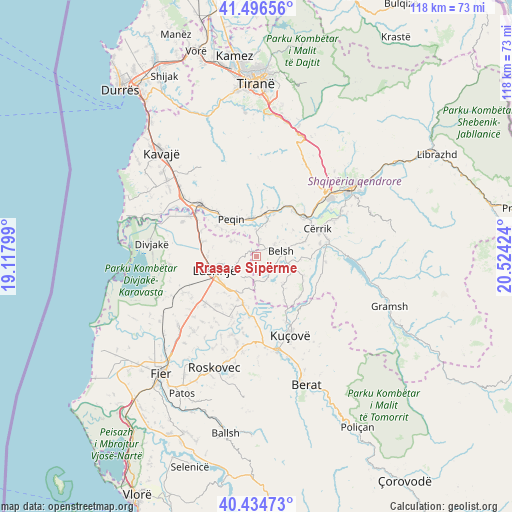
Rrasa e Sipërme GPS coordinates[2]
40° 58' 4.008" North, 19° 49' 15.996" East
| Map corner | latitude | longitude |
|---|---|---|
| Upper-left | 41.49656°, | 19.11799° |
| Center: | 40.96778°, | 19.82111° |
| Lower-right: | 40.43473°, | 20.52424° |
| Map W x H: | 118.1×118.1 km | = 73.4×73.4mi |
| max Lat: | 42.45139° ⇑54.6% North |
| Rrasa e Sipërme: | 40.96778° |
| min Lat: | ⇓45.4% South 39.65889° |
| min Long | Rrasa e Sipërm | max Long |
| 19.40556° | 19.82111° | 20.99° |
| W 36.6%⇐ | ⇒63.4% E |
Elevation
Elevation of Rrasa e Sipërme is 153 m = 502 ft, and this is 221.6 m = 727 ft below average elevation for this country.
| Max E: |
1352 m = 4436 ft | 62% |
| Avg. | 374.6 m = 1229 ft | |
| Rrasa e Sipërme | 153 m = 502 ft | |
Min E: |
-2 m = -7 ft | 38% |
See also: Albania elevation on elevation.city.
Geographical zone
Rrasa e Sipërme is located in North temperate zone (between Tropic of Cancer and the Arctic Circle). Distance of this Northern Tropic circle is 1949.3 km =1211.2 mi to South.| Distance of | km | miles | from Rrasa e Sipërme |
|---|---|---|---|
| North Pole | 5451.9 | 3387.7 | to North |
| Arctic Circle | 2846 | 1768.4 | to North |
| Tropic Cancer | 1949.3 | 1211.2 | to South |
| Equator | 4555.2 | 2830.5 | to South |


Nearby cities:
15 places around Rrasa e Sipërme: (largest is in red/bold)
• Ballagat
5.6 km =3.5 mi,  303°
303°
• Belsh
5.2 km =3.2 mi,  81°
81°
• Fierzë
5.7 km =3.5 mi,  157°
157°
• Gjoçaj
10.4 km =6.5 mi,  308°
308°
• Golem
11.4 km =7.1 mi,  270°
270°
• Grekan
11.4 km =7.1 mi,  111°
111°
• Hysgjokaj
2.7 km =1.7 mi,  279°
279°
• Kajan
8.3 km =5.2 mi,  136°
136°
• Karbunara e Vogël
10.1 km =6.3 mi,  239°
239°
• Lushnjë
10.2 km =6.3 mi,  253°
253°
• Pajovë
9.8 km =6.1 mi,  8°
8°
• Peqin
10.5 km =6.5 mi,  326°
326°
• Përparim
9.3 km =5.8 mi,  348°
348°
• Shalës
11.2 km =7 mi,  72°
72°
• Shezë
6.3 km =3.9 mi,  356°
356°
Sources, notices
• [Note1] Compared only with cities in Albania existing in our database
• [Src1] Map data: © OpenStreetMap contributors (CC-BY-SA)
• [Src2] Other city data from geonames.org with taken over terms of usage.
• [Src3] Geographical zone / Annual Mean Temperature by Robert A. Rohde @ Wikipedia
