Kajan geodata
Kajan (Elbasan) is a seat of a third-order administrative division; located in Albania in Europe/Tirane (GMT+2) time zone. In our database, there are 71 cities with bigger population. Compared to other cities in Albania, 57.7% of cities are located further ↑North; 58.6% of cities are located further →East and 59.7% of cities have higher elevation than Kajan. Note1


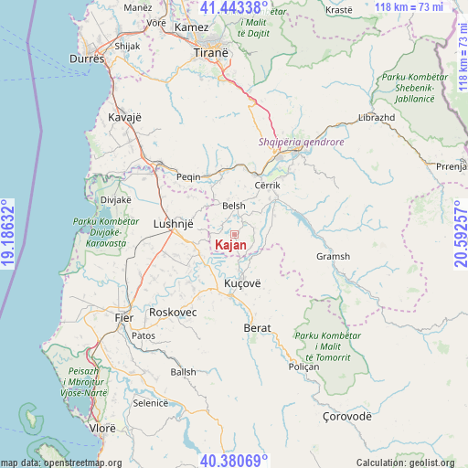
Kajan GPS coordinates[2]
40° 54' 51.012" North, 19° 53' 21.984" East
| Map corner | latitude | longitude |
|---|---|---|
| Upper-left | 41.44338°, | 19.18632° |
| Center: | 40.91417°, | 19.88944° |
| Lower-right: | 40.38069°, | 20.59257° |
| Map W x H: | 118.2×118.2 km | = 73.4×73.4mi |
| max Lat: | 42.45139° ⇑57.7% North |
| Kajan: | 40.91417° |
| min Lat: | ⇓42.3% South 39.65889° |
| min Long | Kajan | max Long |
| 19.40556° | 19.88944° | 20.99° |
| W 41.4%⇐ | ⇒58.6% E |
Elevation
Elevation of Kajan is 173 m = 568 ft, and this is 201.6 m = 661 ft below average elevation for this country.
| Max E: |
1352 m = 4436 ft | 59.7% |
| Avg. | 374.6 m = 1229 ft | |
| Kajan | 173 m = 568 ft | |
Min E: |
-2 m = -7 ft | 40.3% |
See also: Albania elevation on elevation.city.
Geographical zone
Kajan is located in North temperate zone (between Tropic of Cancer and the Arctic Circle). Distance of this Northern Tropic circle is 1943.3 km =1207.5 mi to South.| Distance of | km | miles | from Kajan |
|---|---|---|---|
| North Pole | 5457.8 | 3391.3 | to North |
| Arctic Circle | 2851.9 | 1772.1 | to North |
| Tropic Cancer | 1943.3 | 1207.5 | to South |
| Equator | 4549.2 | 2826.7 | to South |


Nearby cities:
15 places around Kajan: (largest is in red/bold)
• Allkaj
12.9 km =8 mi,  240°
240°
• Ballagat
13.8 km =8.6 mi,  310°
310°
• Banaj
10.7 km =6.6 mi,  202°
202°
• Belsh
6.8 km =4.2 mi,  354°
354°
• Fier-Shegan
10.2 km =6.3 mi, 239°
• Fierzë
3.6 km =2.2 mi,  281°
281°
• Grekan
5.2 km =3.2 mi,  70°
70°
• Hysgjokaj
10.5 km =6.5 mi, 307°
• Klos
10.7 km =6.6 mi, 70°
• Kozarë
9.3 km =5.8 mi,  174°
174°
• Kuçovë
12.9 km =8 mi, 169°
• Mollas
9.7 km =6 mi,  81°
81°
• Rrasa e Sipërme
8.3 km =5.2 mi,  316°
316°
• Shalës
10.6 km =6.6 mi,  27°
27°
• Shezë
13.7 km =8.5 mi,  333°
333°
Sources, notices
• [Note1] Compared only with cities in Albania existing in our database
• [Src1] Map data: © OpenStreetMap contributors (CC-BY-SA)
• [Src2] Other city data from geonames.org with taken over terms of usage.
• [Src3] Geographical zone / Annual Mean Temperature by Robert A. Rohde @ Wikipedia
