Funarë geodata
Funarë (Elbasan) is a seat of a third-order administrative division; located in Albania in Europe/Tirane (GMT+2) time zone. In our database, there are 71 cities with bigger population. Compared to other cities in Albania, 58.6% of cities are located further ↓South; 57.7% of cities are located further ←West and 78% of cities have lower elevation than Funarë. Note1


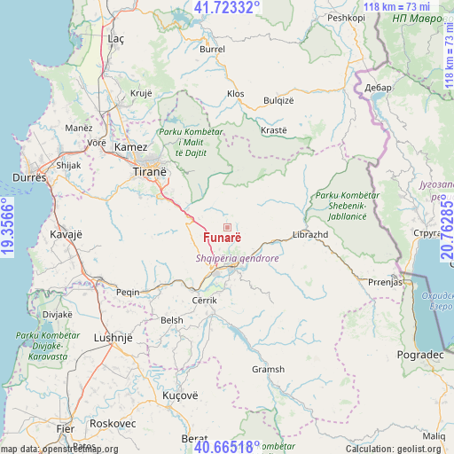
Funarë GPS coordinates[2]
41° 11' 47.004" North, 20° 3' 34.992" East
| Map corner | latitude | longitude |
|---|---|---|
| Upper-left | 41.72332°, | 19.3566° |
| Center: | 41.19639°, | 20.05972° |
| Lower-right: | 40.66518°, | 20.76285° |
| Map W x H: | 117.7×117.7 km | = 73.1×73.1mi |
| max Lat: | 42.45139° ⇑41.4% North |
| Funarë: | 41.19639° |
| min Lat: | ⇓58.6% South 39.65889° |
| min Long | Funarë | max Long |
| 19.40556° | 20.05972° | 20.99° |
| W 57.7%⇐ | ⇒42.3% E |
Elevation
Elevation of Funarë is 729 m = 2392 ft, and this is 354.4 m = 1163 ft above average elevation for this country.
| Max E: |
1352 m = 4436 ft | 22% |
| Funarë | 729 m 2392 ft | |
| Avg. | 374.6 m = 1229 ft | |
Min E: |
-2 m = -7 ft | 78% |
See also: Albania elevation on elevation.city.
Geographical zone
Funarë is located in North temperate zone (between Tropic of Cancer and the Arctic Circle). Distance of this Northern Tropic circle is 1974.7 km =1227 mi to South.| Distance of | km | miles | from Funarë |
|---|---|---|---|
| North Pole | 5426.5 | 3371.9 | to North |
| Arctic Circle | 2820.6 | 1752.6 | to North |
| Tropic Cancer | 1974.7 | 1227 | to South |
| Equator | 4580.6 | 2846.3 | to South |


Nearby cities:
15 places around Funarë: (largest is in red/bold)
• Bradashesh
10.6 km =6.6 mi,  197°
197°
• Bërzhitë
14.3 km =8.9 mi,  292°
292°
• Elbasan
9.5 km =5.9 mi,  168°
168°
• Gjergjan
17.2 km =10.7 mi,  188°
188°
• Gostimë
16.1 km =10 mi,  110°
110°
• Gracen
9.4 km =5.8 mi,  238°
238°
• Krrabë
7.7 km =4.8 mi, 286°
• Labinot-Fushë
9.5 km =5.9 mi,  130°
130°
• Labinot-Mal
7.8 km =4.8 mi,  86°
86°
• Orenjë
16.1 km =10 mi,  52°
52°
• Papër
18.1 km =11.2 mi,  207°
207°
• Petrelë
18.4 km =11.4 mi, 290°
• Polis-Gostimë
18 km =11.2 mi, 112°
• Shirgjan
16.1 km =10 mi,  181°
181°
• Shushicë
13.3 km =8.3 mi,  145°
145°
Sources, notices
• [Note1] Compared only with cities in Albania existing in our database
• [Src1] Map data: © OpenStreetMap contributors (CC-BY-SA)
• [Src2] Other city data from geonames.org with taken over terms of usage.
• [Src3] Geographical zone / Annual Mean Temperature by Robert A. Rohde @ Wikipedia
