Kotë geodata
Kotë (Vlorë) is a seat of a third-order administrative division; located in Albania in Europe/Tirane (GMT+2) time zone. In our database, there are 71 cities with bigger population. Compared to other cities in Albania, 87.9% of cities are located further ↑North; 87.3% of cities are located further →East and 70.1% of cities have higher elevation than Kotë. Note1


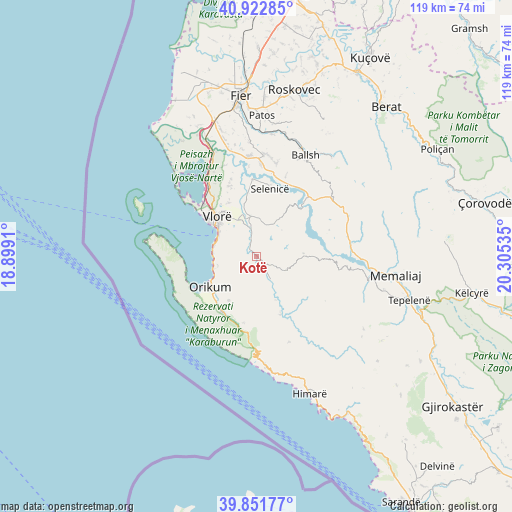
Kotë GPS coordinates[2]
40° 23' 21.984" North, 19° 36' 7.992" East
| Map corner | latitude | longitude |
|---|---|---|
| Upper-left | 40.92285°, | 18.8991° |
| Center: | 40.38944°, | 19.60222° |
| Lower-right: | 39.85177°, | 20.30535° |
| Map W x H: | 119.1×119.1 km | = 74×74mi |
| max Lat: | 42.45139° ⇑87.9% North |
| Kotë: | 40.38944° |
| min Lat: | ⇓12.1% South 39.65889° |
| min Long | Kotë | max Long |
| 19.40556° | 19.60222° | 20.99° |
| W 12.7%⇐ | ⇒87.3% E |
Elevation
Elevation of Kotë is 82 m = 269 ft, and this is 292.6 m = 960 ft below average elevation for this country.
| Max E: |
1352 m = 4436 ft | 70.1% |
| Avg. | 374.6 m = 1229 ft | |
| Kotë | 82 m = 269 ft | |
Min E: |
-2 m = -7 ft | 29.9% |
See also: Albania elevation on elevation.city.
Geographical zone
Kotë is located in North temperate zone (between Tropic of Cancer and the Arctic Circle). Distance of this Northern Tropic circle is 1885 km =1171.3 mi to South.| Distance of | km | miles | from Kotë |
|---|---|---|---|
| North Pole | 5516.2 | 3427.6 | to North |
| Arctic Circle | 2910.3 | 1808.4 | to North |
| Tropic Cancer | 1885 | 1171.3 | to South |
| Equator | 4490.9 | 2790.5 | to South |


Nearby cities:
15 places around Kotë: (largest is in red/bold)
• Armen
16.3 km =10.1 mi,  358°
358°
• Brataj
14.7 km =9.1 mi,  157°
157°
• Cakran
23.9 km =14.9 mi,  4°
4°
• Drenovë
24.9 km =15.5 mi,  19°
19°
• Fratar
21.9 km =13.6 mi,  55°
55°
• Greshicë
23.4 km =14.5 mi,  39°
39°
• Hekal
22.3 km =13.9 mi,  30°
30°
• Krahës
21.2 km =13.2 mi,  75°
75°
• Kutë
16.7 km =10.4 mi, 56°
• Orikum
13.2 km =8.2 mi,  237°
237°
• Selenicë
15.9 km =9.9 mi,  10°
10°
• Sevaster
10.8 km =6.7 mi,  85°
85°
• Vllahinë
8.3 km =5.2 mi, 25°
• Vlorë
13.4 km =8.3 mi,  311°
311°
• Vranisht
21.3 km =13.2 mi, 159°
Sources, notices
• [Note1] Compared only with cities in Albania existing in our database
• [Src1] Map data: © OpenStreetMap contributors (CC-BY-SA)
• [Src2] Other city data from geonames.org with taken over terms of usage.
• [Src3] Geographical zone / Annual Mean Temperature by Robert A. Rohde @ Wikipedia
