Sevaster geodata
Sevaster (Vlorë) is a seat of a third-order administrative division; located in Albania in Europe/Tirane (GMT+2) time zone. In our database, there are 71 cities with bigger population. Compared to other cities in Albania, 87.6% of cities are located further ↑North; 73% of cities are located further →East and 56.3% of cities have lower elevation than Sevaster. Note1


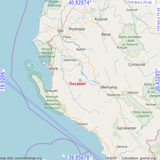
Sevaster GPS coordinates[2]
40° 23' 47.004" North, 19° 43' 46.992" East
| Map corner | latitude | longitude |
|---|---|---|
| Upper-left | 40.92974°, | 19.0266° |
| Center: | 40.39639°, | 19.72972° |
| Lower-right: | 39.85878°, | 20.43285° |
| Map W x H: | 119.1×119.1 km | = 74×74mi |
| max Lat: | 42.45139° ⇑87.6% North |
| Sevaster: | 40.39639° |
| min Lat: | ⇓12.4% South 39.65889° |
| min Long | Sevaster | max Long |
| 19.40556° | 19.72972° | 20.99° |
| W 27%⇐ | ⇒73% E |
Elevation
Elevation of Sevaster is 339 m = 1112 ft, and this is 35.6 m = 117 ft below average elevation for this country.
| Max E: |
1352 m = 4436 ft | 43.7% |
| Avg. | 374.6 m = 1229 ft | |
| Sevaster | 339 m = 1112 ft | |
Min E: |
-2 m = -7 ft | 56.3% |
See also: Albania elevation on elevation.city.
Geographical zone
Sevaster is located in North temperate zone (between Tropic of Cancer and the Arctic Circle). Distance of this Northern Tropic circle is 1885.7 km =1171.7 mi to South.| Distance of | km | miles | from Sevaster |
|---|---|---|---|
| North Pole | 5515.4 | 3427.1 | to North |
| Arctic Circle | 2909.5 | 1807.9 | to North |
| Tropic Cancer | 1885.7 | 1171.7 | to South |
| Equator | 4491.7 | 2791 | to South |


Nearby cities:
15 places around Sevaster: (largest is in red/bold)
• Armen
19.2 km =11.9 mi,  324°
324°
• Brataj
15.2 km =9.4 mi,  199°
199°
• Fratar
13.7 km =8.5 mi,  32°
32°
• Greshicë
17.8 km =11.1 mi,  13°
13°
• Hekal
18.4 km =11.4 mi,  1°
1°
• Kalenjë
21.9 km =13.6 mi, 10°
• Kotë
10.8 km =6.7 mi,  265°
265°
• Krahës
10.8 km =6.7 mi,  64°
64°
• Kutë
9.1 km =5.7 mi,  19°
19°
• Luftinjë
19.7 km =12.2 mi,  74°
74°
• Memaliaj
21.8 km =13.5 mi,  103°
103°
• Selenicë
16.9 km =10.5 mi,  331°
331°
• Selitë
19.6 km =12.2 mi, 30°
• Vllahinë
9.9 km =6.2 mi,  312°
312°
• Vranisht
21 km =13 mi,  189°
189°
Sources, notices
• [Note1] Compared only with cities in Albania existing in our database
• [Src1] Map data: © OpenStreetMap contributors (CC-BY-SA)
• [Src2] Other city data from geonames.org with taken over terms of usage.
• [Src3] Geographical zone / Annual Mean Temperature by Robert A. Rohde @ Wikipedia
