Vllahinë geodata
Vllahinë (Vlorë) is a seat of a third-order administrative division; located in Albania in Europe/Tirane (GMT+2) time zone. In our database, there are 71 cities with bigger population. Compared to other cities in Albania, 85.4% of cities are located further ↑North; 82.8% of cities are located further →East and 64.8% of cities have higher elevation than Vllahinë. Note1


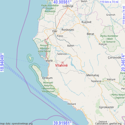
Vllahinë GPS coordinates[2]
40° 27' 24.984" North, 19° 38' 36.996" East
| Map corner | latitude | longitude |
|---|---|---|
| Upper-left | 40.98981°, | 18.94049° |
| Center: | 40.45694°, | 19.64361° |
| Lower-right: | 39.91981°, | 20.34674° |
| Map W x H: | 119×119 km | = 73.9×73.9mi |
| max Lat: | 42.45139° ⇑85.4% North |
| Vllahinë: | 40.45694° |
| min Lat: | ⇓14.6% South 39.65889° |
| min Long | Vllahinë | max Long |
| 19.40556° | 19.64361° | 20.99° |
| W 17.2%⇐ | ⇒82.8% E |
Elevation
Elevation of Vllahinë is 121 m = 397 ft, and this is 253.6 m = 832 ft below average elevation for this country.
| Max E: |
1352 m = 4436 ft | 64.8% |
| Avg. | 374.6 m = 1229 ft | |
| Vllahinë | 121 m = 397 ft | |
Min E: |
-2 m = -7 ft | 35.2% |
See also: Albania elevation on elevation.city.
Geographical zone
Vllahinë is located in North temperate zone (between Tropic of Cancer and the Arctic Circle). Distance of this Northern Tropic circle is 1892.5 km =1175.9 mi to South.| Distance of | km | miles | from Vllahinë |
|---|---|---|---|
| North Pole | 5508.7 | 3422.9 | to North |
| Arctic Circle | 2902.8 | 1803.7 | to North |
| Tropic Cancer | 1892.5 | 1175.9 | to South |
| Equator | 4498.4 | 2795.2 | to South |


Nearby cities:
15 places around Vllahinë: (largest is in red/bold)
• Armen
9.7 km =6 mi,  335°
335°
• Ballsh
17.6 km =10.9 mi,  26°
26°
• Cakran
16.3 km =10.1 mi,  354°
354°
• Drenovë
16.7 km =10.4 mi,  16°
16°
• Fratar
15.4 km =9.6 mi,  71°
71°
• Greshicë
15.5 km =9.6 mi,  47°
47°
• Hekal
14 km =8.7 mi, 33°
• Kalenjë
18.7 km =11.6 mi,  37°
37°
• Kotë
8.3 km =5.2 mi,  205°
205°
• Krahës
17.1 km =10.6 mi,  96°
96°
• Kutë
10.5 km =6.5 mi,  80°
80°
• Selenicë
8.2 km =5.1 mi,  355°
355°
• Selitë
20 km =12.4 mi,  59°
59°
• Sevaster
9.9 km =6.2 mi,  132°
132°
• Vlorë
13.6 km =8.5 mi,  275°
275°
Sources, notices
• [Note1] Compared only with cities in Albania existing in our database
• [Src1] Map data: © OpenStreetMap contributors (CC-BY-SA)
• [Src2] Other city data from geonames.org with taken over terms of usage.
• [Src3] Geographical zone / Annual Mean Temperature by Robert A. Rohde @ Wikipedia
