Kutë geodata
Kutë (Fier) is a seat of a third-order administrative division; located in Albania in Europe/Tirane (GMT+2) time zone. In our database, there are 71 cities with bigger population. Compared to other cities in Albania, 84.8% of cities are located further ↑North; 68.7% of cities are located further →East and 62.5% of cities have higher elevation than Kutë. Note1


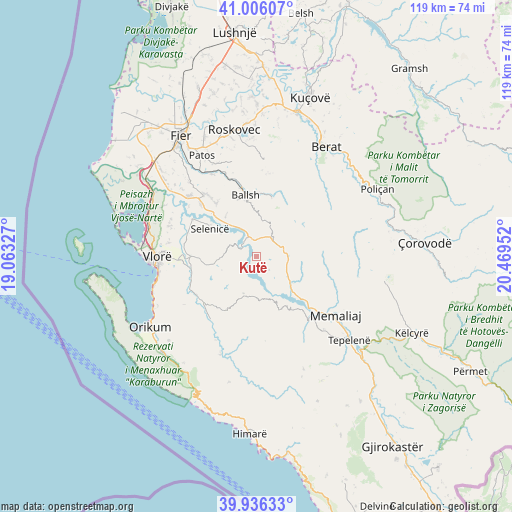
Kutë GPS coordinates[2]
40° 28' 23.988" North, 19° 45' 59.004" East
| Map corner | latitude | longitude |
|---|---|---|
| Upper-left | 41.00607°, | 19.06327° |
| Center: | 40.47333°, | 19.76639° |
| Lower-right: | 39.93633°, | 20.46952° |
| Map W x H: | 118.9×118.9 km | = 73.9×73.9mi |
| max Lat: | 42.45139° ⇑84.8% North |
| Kutë: | 40.47333° |
| min Lat: | ⇓15.2% South 39.65889° |
| min Long | Kutë | max Long |
| 19.40556° | 19.76639° | 20.99° |
| W 31.3%⇐ | ⇒68.7% E |
Elevation
Elevation of Kutë is 141 m = 463 ft, and this is 233.6 m = 766 ft below average elevation for this country.
| Max E: |
1352 m = 4436 ft | 62.5% |
| Avg. | 374.6 m = 1229 ft | |
| Kutë | 141 m = 463 ft | |
Min E: |
-2 m = -7 ft | 37.5% |
See also: Albania elevation on elevation.city.
Geographical zone
Kutë is located in North temperate zone (between Tropic of Cancer and the Arctic Circle). Distance of this Northern Tropic circle is 1894.3 km =1177.1 mi to South.| Distance of | km | miles | from Kutë |
|---|---|---|---|
| North Pole | 5506.8 | 3421.8 | to North |
| Arctic Circle | 2901 | 1802.6 | to North |
| Tropic Cancer | 1894.3 | 1177.1 | to South |
| Equator | 4500.2 | 2796.3 | to South |


Nearby cities:
15 places around Kutë: (largest is in red/bold)
• Aranitas
13.9 km =8.6 mi,  14°
14°
• Armen
16 km =9.9 mi,  295°
295°
• Ballsh
14.2 km =8.8 mi,  349°
349°
• Drenovë
15.2 km =9.4 mi,  338°
338°
• Fratar
5.2 km =3.2 mi,  55°
55°
• Greshicë
8.8 km =5.5 mi, 6°
• Hekal
10.2 km =6.3 mi, 345°
• Kalenjë
13 km =8.1 mi,  4°
4°
• Kotë
16.7 km =10.4 mi,  236°
236°
• Krahës
7.6 km =4.7 mi,  120°
120°
• Luftinjë
16.3 km =10.1 mi,  102°
102°
• Selenicë
12.7 km =7.9 mi, 299°
• Selitë
10.8 km =6.7 mi,  39°
39°
• Sevaster
9.1 km =5.7 mi,  199°
199°
• Vllahinë
10.5 km =6.5 mi,  260°
260°
Sources, notices
• [Note1] Compared only with cities in Albania existing in our database
• [Src1] Map data: © OpenStreetMap contributors (CC-BY-SA)
• [Src2] Other city data from geonames.org with taken over terms of usage.
• [Src3] Geographical zone / Annual Mean Temperature by Robert A. Rohde @ Wikipedia
