Manzë geodata
Manzë (Durrës) is a seat of a third-order administrative division; located in Albania in Europe/Tirane (GMT+2) time zone. In our database, there are 71 cities with bigger population. Compared to other cities in Albania, 68.5% of cities are located further ↓South; 88.5% of cities are located further →East and 76.1% of cities have higher elevation than Manzë. Note1


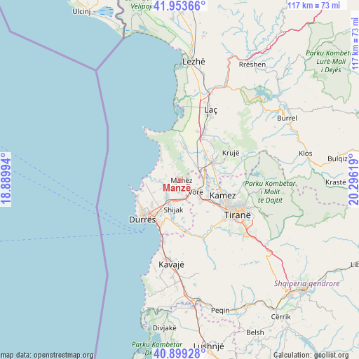
Manzë GPS coordinates[2]
41° 25' 42.996" North, 19° 35' 35.016" East
| Map corner | latitude | longitude |
|---|---|---|
| Upper-left | 41.95366°, | 18.88994° |
| Center: | 41.42861°, | 19.59306° |
| Lower-right: | 40.89928°, | 20.29619° |
| Map W x H: | 117.2×117.2 km | = 72.8×72.8mi |
| max Lat: | 42.45139° ⇑31.5% North |
| Manzë: | 41.42861° |
| min Lat: | ⇓68.5% South 39.65889° |
| min Long | Manzë | max Long |
| 19.40556° | 19.59306° | 20.99° |
| W 11.5%⇐ | ⇒88.5% E |
Elevation
Elevation of Manzë is 49 m = 161 ft, and this is 325.6 m = 1068 ft below average elevation for this country.
| Max E: |
1352 m = 4436 ft | 76.1% |
| Avg. | 374.6 m = 1229 ft | |
| Manzë | 49 m = 161 ft | |
Min E: |
-2 m = -7 ft | 23.9% |
See also: Albania elevation on elevation.city.
Geographical zone
Manzë is located in North temperate zone (between Tropic of Cancer and the Arctic Circle). Distance of this Northern Tropic circle is 2000.5 km =1243.1 mi to South.| Distance of | km | miles | from Manzë |
|---|---|---|---|
| North Pole | 5400.6 | 3355.8 | to North |
| Arctic Circle | 2794.7 | 1736.5 | to North |
| Tropic Cancer | 2000.5 | 1243.1 | to South |
| Equator | 4606.4 | 2862.3 | to South |


Nearby cities:
15 places around Manzë: (largest is in red/bold)
• Bubq
7 km =4.3 mi,  43°
43°
• Bërxull
9.6 km =6 mi,  124°
124°
• Fushë-Krujë
11.8 km =7.3 mi,  61°
61°
• Gjepalaj
10.7 km =6.6 mi,  186°
186°
• Hasan
10.7 km =6.6 mi, 55°
• Ishëm
13 km =8.1 mi,  2°
2°
• Kashar
13.1 km =8.1 mi,  131°
131°
• Katundi i Ri
6.9 km =4.3 mi,  245°
245°
• Maminas
5.6 km =3.5 mi,  167°
167°
• Nikël
13.1 km =8.1 mi,  82°
82°
• Prezë
6.6 km =4.1 mi,  91°
91°
• Shijak
9.5 km =5.9 mi, 193°
• Sukth
7.1 km =4.4 mi,  220°
220°
• Vorë
6.7 km =4.2 mi, 129°
• Xhafzotaj
10.1 km =6.3 mi,  202°
202°
Sources, notices
• [Note1] Compared only with cities in Albania existing in our database
• [Src1] Map data: © OpenStreetMap contributors (CC-BY-SA)
• [Src2] Other city data from geonames.org with taken over terms of usage.
• [Src3] Geographical zone / Annual Mean Temperature by Robert A. Rohde @ Wikipedia
