Nicaj-Shalë geodata
Nicaj-Shalë (Shkodër) is a seat of a third-order administrative division; located in Albania in Europe/Tirane (GMT+2) time zone. In our database, there are 71 cities with bigger population. Compared to other cities in Albania, 98% of cities are located further ↓South; 65.1% of cities are located further →East and 73% of cities have lower elevation than Nicaj-Shalë. Note1


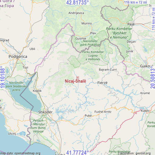
Nicaj-Shalë GPS coordinates[2]
42° 17' 57.984" North, 19° 48' 18" East
| Map corner | latitude | longitude |
|---|---|---|
| Upper-left | 42.81735°, | 19.10188° |
| Center: | 42.29944°, | 19.805° |
| Lower-right: | 41.77724°, | 20.50813° |
| Map W x H: | 115.6×115.6 km | = 71.8×71.8mi |
| max Lat: | 42.45139° ⇑2% North |
| Nicaj-Shalë: | 42.29944° |
| min Lat: | ⇓98% South 39.65889° |
| min Long | Nicaj-Shalë | max Long |
| 19.40556° | 19.805° | 20.99° |
| W 34.9%⇐ | ⇒65.1% E |
Elevation
Elevation of Nicaj-Shalë is 633 m = 2077 ft, and this is 258.4 m = 848 ft above average elevation for this country.
| Max E: |
1352 m = 4436 ft | 27% |
| Nicaj-Shalë | 633 m 2077 ft | |
| Avg. | 374.6 m = 1229 ft | |
Min E: |
-2 m = -7 ft | 73% |
See also: Albania elevation on elevation.city.
Geographical zone
Nicaj-Shalë is located in North temperate zone (between Tropic of Cancer and the Arctic Circle). Distance of this Northern Tropic circle is 2097.3 km =1303.2 mi to South.| Distance of | km | miles | from Nicaj-Shalë |
|---|---|---|---|
| North Pole | 5303.8 | 3295.6 | to North |
| Arctic Circle | 2697.9 | 1676.4 | to North |
| Tropic Cancer | 2097.3 | 1303.2 | to South |
| Equator | 4703.3 | 2922.5 | to South |


Nearby cities:
15 places around Nicaj-Shalë: (largest is in red/bold)
• Bajram Curri
23.3 km =14.5 mi,  73°
73°
• Bujan
22.5 km =14 mi,  82°
82°
• Bushat
21.5 km =13.4 mi,  158°
158°
• Fierzë
18 km =11.2 mi,  103°
103°
• Grudë-Fushë
29.6 km =18.4 mi,  238°
238°
• Gruemirë
28.3 km =17.6 mi, 236°
• Iballë
20.5 km =12.7 mi,  127°
127°
• Kastrat
26.6 km =16.5 mi,  282°
282°
• Lekbibaj
10.4 km =6.5 mi,  92°
92°
• Llugaj
25.4 km =15.8 mi, 79°
• Nicaj-Shosh
7.2 km =4.5 mi,  212°
212°
• Pukë
29.4 km =18.3 mi, 164°
• Qelëz
24.5 km =15.2 mi, 162°
• Qerret
27.5 km =17.1 mi,  174°
174°
• Valbonë
18.3 km =11.4 mi,  22°
22°
Sources, notices
• [Note1] Compared only with cities in Albania existing in our database
• [Src1] Map data: © OpenStreetMap contributors (CC-BY-SA)
• [Src2] Other city data from geonames.org with taken over terms of usage.
• [Src3] Geographical zone / Annual Mean Temperature by Robert A. Rohde @ Wikipedia
