Lukovë geodata
Lukovë (Vlorë) is a seat of a third-order administrative division; located in Albania in Europe/Tirane (GMT+2) time zone. In our database, there are 71 cities with bigger population. Compared to other cities in Albania, 96.6% of cities are located further ↑North; 56.1% of cities are located further →East and 54.4% of cities have higher elevation than Lukovë. Note1


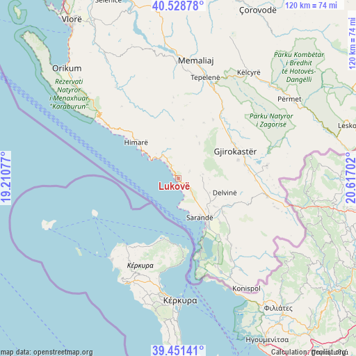
Lukovë GPS coordinates[2]
39° 59' 31.992" North, 19° 54' 50.004" East
| Map corner | latitude | longitude |
|---|---|---|
| Upper-left | 40.52878°, | 19.21077° |
| Center: | 39.99222°, | 19.91389° |
| Lower-right: | 39.45141°, | 20.61702° |
| Map W x H: | 119.8×119.8 km | = 74.4×74.4mi |
| max Lat: | 42.45139° ⇑96.6% North |
| Lukovë: | 39.99222° |
| min Lat: | ⇓3.4% South 39.65889° |
| min Long | Lukovë | max Long |
| 19.40556° | 19.91389° | 20.99° |
| W 43.9%⇐ | ⇒56.1% E |
Elevation
Elevation of Lukovë is 229 m = 751 ft, and this is 145.6 m = 478 ft below average elevation for this country.
| Max E: |
1352 m = 4436 ft | 54.4% |
| Avg. | 374.6 m = 1229 ft | |
| Lukovë | 229 m = 751 ft | |
Min E: |
-2 m = -7 ft | 45.6% |
See also: Albania elevation on elevation.city.
Geographical zone
Lukovë is located in North temperate zone (between Tropic of Cancer and the Arctic Circle). Distance of this Northern Tropic circle is 1840.8 km =1143.8 mi to South.| Distance of | km | miles | from Lukovë |
|---|---|---|---|
| North Pole | 5560.3 | 3455 | to North |
| Arctic Circle | 2954.5 | 1835.8 | to North |
| Tropic Cancer | 1840.8 | 1143.8 | to South |
| Equator | 4446.7 | 2763.1 | to South |


Nearby cities:
15 places around Lukovë: (largest is in red/bold)
• Aliko
20.5 km =12.7 mi,  136°
136°
• Delvinë
16.3 km =10.1 mi,  106°
106°
• Dhivër
27.8 km =17.3 mi,  128°
128°
• Finiq
15.6 km =9.7 mi, 127°
• Gjirokastër
21.3 km =13.2 mi,  64°
64°
• Himarë
18.9 km =11.7 mi,  310°
310°
• Kardhiq
17.3 km =10.7 mi,  33°
33°
• Ksamil
25.9 km =16.1 mi,  163°
163°
• Lazarat
20.8 km =12.9 mi,  73°
73°
• Mesopotam
17.7 km =11 mi,  120°
120°
• Odrie
26.6 km =16.5 mi,  53°
53°
• Picar
22.5 km =14 mi, 30°
• Progonat
24.7 km =15.3 mi,  6°
6°
• Sarandë
15.1 km =9.4 mi,  149°
149°
• Vergo
8.2 km =5.1 mi,  78°
78°
Sources, notices
• [Note1] Compared only with cities in Albania existing in our database
• [Src1] Map data: © OpenStreetMap contributors (CC-BY-SA)
• [Src2] Other city data from geonames.org with taken over terms of usage.
• [Src3] Geographical zone / Annual Mean Temperature by Robert A. Rohde @ Wikipedia
