Gjegjan geodata
Gjegjan (Shkodër) is a seat of a third-order administrative division; located in Albania in Europe/Tirane (GMT+2) time zone. In our database, there are 71 cities with bigger population. Compared to other cities in Albania, 87.9% of cities are located further ↓South; 52.7% of cities are located further ←West and 58.3% of cities have lower elevation than Gjegjan. Note1


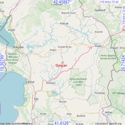
Gjegjan GPS coordinates[2]
41° 56' 16.008" North, 20° 0' 39.996" East
| Map corner | latitude | longitude |
|---|---|---|
| Upper-left | 42.45867°, | 19.30799° |
| Center: | 41.93778°, | 20.01111° |
| Lower-right: | 41.4126°, | 20.71424° |
| Map W x H: | 116.3×116.3 km | = 72.3×72.3mi |
| max Lat: | 42.45139° ⇑12.1% North |
| Gjegjan: | 41.93778° |
| min Lat: | ⇓87.9% South 39.65889° |
| min Long | Gjegjan | max Long |
| 19.40556° | 20.01111° | 20.99° |
| W 52.7%⇐ | ⇒47.3% E |
Elevation
Elevation of Gjegjan is 369 m = 1211 ft, and this is 5.6 m = 18 ft below average elevation for this country.
| Max E: |
1352 m = 4436 ft | 41.7% |
| Avg. | 374.6 m = 1229 ft | |
| Gjegjan | 369 m = 1211 ft | |
Min E: |
-2 m = -7 ft | 58.3% |
See also: Albania elevation on elevation.city.
Geographical zone
Gjegjan is located in North temperate zone (between Tropic of Cancer and the Arctic Circle). Distance of this Northern Tropic circle is 2057.1 km =1278.2 mi to South.| Distance of | km | miles | from Gjegjan |
|---|---|---|---|
| North Pole | 5344 | 3320.6 | to North |
| Arctic Circle | 2738.1 | 1701.4 | to North |
| Tropic Cancer | 2057.1 | 1278.2 | to South |
| Equator | 4663 | 2897.5 | to South |


Nearby cities:
15 places around Gjegjan: (largest is in red/bold)
• Blinisht
8.5 km =5.3 mi,  186°
186°
• Bushat
22.2 km =13.8 mi,  335°
335°
• Fushë-Arrëz
13.8 km =8.6 mi,  1°
1°
• Kaçinar
10.5 km =6.5 mi,  242°
242°
• Kthella e Epërme
14.5 km =9 mi,  164°
164°
• Kurbnesh
18.6 km =11.6 mi, 161°
• Orosh
13.1 km =8.1 mi,  152°
152°
• Pukë
15 km =9.3 mi,  322°
322°
• Qafëmal
18.5 km =11.5 mi,  20°
20°
• Qelëz
19.4 km =12.1 mi,  330°
330°
• Qerret
19.3 km =12 mi,  311°
311°
• Rrapë
12.3 km =7.6 mi, 344°
• Rrëshen
22 km =13.7 mi,  210°
210°
• Shëngjin
14.7 km =9.1 mi,  95°
95°
• Ungrej
19.2 km =11.9 mi,  248°
248°
Sources, notices
• [Note1] Compared only with cities in Albania existing in our database
• [Src1] Map data: © OpenStreetMap contributors (CC-BY-SA)
• [Src2] Other city data from geonames.org with taken over terms of usage.
• [Src3] Geographical zone / Annual Mean Temperature by Robert A. Rohde @ Wikipedia
