Hotolisht geodata
Hotolisht (Elbasan) is a seat of a third-order administrative division; located in Albania in Europe/Tirane (GMT+2) time zone. In our database, there are 71 cities with bigger population. Compared to other cities in Albania, 56.9% of cities are located further ↓South; 82.3% of cities are located further ←West and 74.4% of cities have lower elevation than Hotolisht. Note1


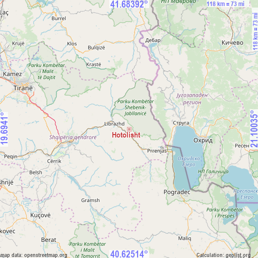
Hotolisht GPS coordinates[2]
41° 9' 24.012" North, 20° 23' 49.992" East
| Map corner | latitude | longitude |
|---|---|---|
| Upper-left | 41.68392°, | 19.6941° |
| Center: | 41.15667°, | 20.39722° |
| Lower-right: | 40.62514°, | 21.10035° |
| Map W x H: | 117.7×117.7 km | = 73.1×73.1mi |
| max Lat: | 42.45139° ⇑43.1% North |
| Hotolisht: | 41.15667° |
| min Lat: | ⇓56.9% South 39.65889° |
| min Long | Hotolisht | max Long |
| 19.40556° | 20.39722° | 20.99° |
| W 82.3%⇐ | ⇒17.7% E |
Elevation
Elevation of Hotolisht is 656 m = 2152 ft, and this is 281.4 m = 923 ft above average elevation for this country.
| Max E: |
1352 m = 4436 ft | 25.6% |
| Hotolisht | 656 m 2152 ft | |
| Avg. | 374.6 m = 1229 ft | |
Min E: |
-2 m = -7 ft | 74.4% |
See also: Albania elevation on elevation.city.
Geographical zone
Hotolisht is located in North temperate zone (between Tropic of Cancer and the Arctic Circle). Distance of this Northern Tropic circle is 1970.3 km =1224.3 mi to South.| Distance of | km | miles | from Hotolisht |
|---|---|---|---|
| North Pole | 5430.9 | 3374.6 | to North |
| Arctic Circle | 2825 | 1755.4 | to North |
| Tropic Cancer | 1970.3 | 1224.3 | to South |
| Equator | 4576.2 | 2843.5 | to South |


Nearby cities:
15 places around Hotolisht: (largest is in red/bold)
• Gostimë
13.2 km =8.2 mi,  264°
264°
• Labinot-Fushë
21.1 km =13.1 mi,  265°
265°
• Librazhd
7.3 km =4.5 mi,  290°
290°
• Librazhd-Qendër
6.8 km =4.2 mi,  310°
310°
• Lunik
16 km =9.9 mi,  337°
337°
• Orenjë
21 km =13 mi, 312°
• Polis-Gostimë
11.9 km =7.4 mi, 257°
• Proptisht
20.9 km =13 mi,  155°
155°
• Përrenjas
15.7 km =9.8 mi,  126°
126°
• Përrenjas-Fshat
15.3 km =9.5 mi, 130°
• Qukës-Shkumbin
8.2 km =5.1 mi,  148°
148°
• Qukës-Skënderbe
8.8 km =5.5 mi, 157°
• Rajcë
16.7 km =10.4 mi,  116°
116°
• Steblevë
21 km =13 mi,  16°
16°
• Stravaj
17 km =10.6 mi,  172°
172°
Sources, notices
• [Note1] Compared only with cities in Albania existing in our database
• [Src1] Map data: © OpenStreetMap contributors (CC-BY-SA)
• [Src2] Other city data from geonames.org with taken over terms of usage.
• [Src3] Geographical zone / Annual Mean Temperature by Robert A. Rohde @ Wikipedia
