Stravaj geodata
Stravaj (Elbasan) is a seat of a third-order administrative division; located in Albania in Europe/Tirane (GMT+2) time zone. In our database, there are 71 cities with bigger population. Compared to other cities in Albania, 52.1% of cities are located further ↑North; 84.8% of cities are located further ←West and 78% of cities have lower elevation than Stravaj. Note1


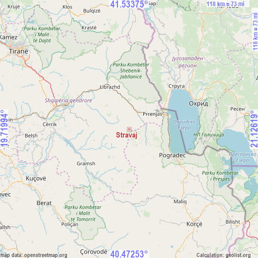
Stravaj GPS coordinates[2]
41° 0' 19.008" North, 20° 25' 23.016" East
| Map corner | latitude | longitude |
|---|---|---|
| Upper-left | 41.53375°, | 19.71994° |
| Center: | 41.00528°, | 20.42306° |
| Lower-right: | 40.47253°, | 21.12619° |
| Map W x H: | 118×118 km | = 73.3×73.3mi |
| max Lat: | 42.45139° ⇑52.1% North |
| Stravaj: | 41.00528° |
| min Lat: | ⇓47.9% South 39.65889° |
| min Long | Stravaj | max Long |
| 19.40556° | 20.42306° | 20.99° |
| W 84.8%⇐ | ⇒15.2% E |
Elevation
Elevation of Stravaj is 729 m = 2392 ft, and this is 354.4 m = 1163 ft above average elevation for this country.
| Max E: |
1352 m = 4436 ft | 22% |
| Stravaj | 729 m 2392 ft | |
| Avg. | 374.6 m = 1229 ft | |
Min E: |
-2 m = -7 ft | 78% |
See also: Albania elevation on elevation.city.
Geographical zone
Stravaj is located in North temperate zone (between Tropic of Cancer and the Arctic Circle). Distance of this Northern Tropic circle is 1953.4 km =1213.8 mi to South.| Distance of | km | miles | from Stravaj |
|---|---|---|---|
| North Pole | 5447.7 | 3385 | to North |
| Arctic Circle | 2841.8 | 1765.8 | to North |
| Tropic Cancer | 1953.4 | 1213.8 | to South |
| Equator | 4559.4 | 2833.1 | to South |


Nearby cities:
15 places around Stravaj: (largest is in red/bold)
• Gjinar
19.7 km =12.2 mi,  275°
275°
• Hotolisht
17 km =10.6 mi,  352°
352°
• Kukur
16.1 km =10 mi,  198°
198°
• Polis-Gostimë
19.8 km =12.3 mi,  315°
315°
• Poroçan
12.6 km =7.8 mi,  236°
236°
• Proptisht
7 km =4.3 mi,  107°
107°
• Përrenjas
13 km =8.1 mi,  54°
54°
• Përrenjas-Fshat
11.6 km =7.2 mi, 54°
• Qukës-Shkumbin
10 km =6.2 mi,  11°
11°
• Qukës-Skënderbe
8.8 km =5.5 mi, 8°
• Rajcë
16 km =9.9 mi, 53°
• Trebinjë
15 km =9.3 mi,  133°
133°
• Udënisht
18.7 km =11.6 mi,  104°
104°
• Velçan
6.5 km =4 mi,  149°
149°
• Zavalinë
12.2 km =7.6 mi,  257°
257°
Sources, notices
• [Note1] Compared only with cities in Albania existing in our database
• [Src1] Map data: © OpenStreetMap contributors (CC-BY-SA)
• [Src2] Other city data from geonames.org with taken over terms of usage.
• [Src3] Geographical zone / Annual Mean Temperature by Robert A. Rohde @ Wikipedia
