Librazhd-Qendër geodata
Librazhd-Qendër (Elbasan) is a seat of a third-order administrative division; located in Albania in Europe/Tirane (GMT+2) time zone. With population of 12,691 people, there are 26 cities with bigger population in this country. Compared to other cities in Albania, 58.9% of cities are located further ↓South; 77.5% of cities are located further ←West and 69% of cities have lower elevation than Librazhd-Qendër. Note1


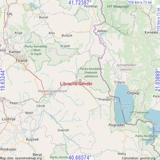
Librazhd-Qendër GPS coordinates[2]
41° 11' 48.984" North, 20° 20' 8.016" East
| Map corner | latitude | longitude |
|---|---|---|
| Upper-left | 41.72387°, | 19.63244° |
| Center: | 41.19694°, | 20.33556° |
| Lower-right: | 40.66574°, | 21.03869° |
| Map W x H: | 117.7×117.7 km | = 73.1×73.1mi |
| max Lat: | 42.45139° ⇑41.1% North |
| Librazhd-Qendër: | 41.19694° |
| min Lat: | ⇓58.9% South 39.65889° |
| min Long | Librazhd-Qendë | max Long |
| 19.40556° | 20.33556° | 20.99° |
| W 77.5%⇐ | ⇒22.5% E |
Elevation
Elevation of Librazhd-Qendër is 554 m = 1818 ft, and this is 179.4 m = 589 ft above average elevation for this country.
| Max E: |
1352 m = 4436 ft | 31% |
| Librazhd-Qendër | 554 m 1818 ft | |
| Avg. | 374.6 m = 1229 ft | |
Min E: |
-2 m = -7 ft | 69% |
See also: Albania elevation on elevation.city.
Geographical zone
Librazhd-Qendër is located in North temperate zone (between Tropic of Cancer and the Arctic Circle). Distance of this Northern Tropic circle is 1974.8 km =1227.1 mi to South.| Distance of | km | miles | from Librazhd-Qendër |
|---|---|---|---|
| North Pole | 5426.4 | 3371.8 | to North |
| Arctic Circle | 2820.5 | 1752.6 | to North |
| Tropic Cancer | 1974.8 | 1227.1 | to South |
| Equator | 4580.7 | 2846.3 | to South |


Nearby cities:
15 places around Librazhd-Qendër: (largest is in red/bold)
• Gostimë
9.8 km =6.1 mi,  234°
234°
• Hotolisht
6.8 km =4.2 mi,  130°
130°
• Labinot-Fushë
17.1 km =10.6 mi,  248°
248°
• Labinot-Mal
15.3 km =9.5 mi,  271°
271°
• Librazhd
2.6 km =1.6 mi,  221°
221°
• Lunik
10.3 km =6.4 mi,  354°
354°
• Orenjë
14.2 km =8.8 mi,  313°
313°
• Polis-Gostimë
9.6 km =6 mi, 222°
• Përrenjas
22.6 km =14 mi, 127°
• Përrenjas-Fshat
22.1 km =13.7 mi, 130°
• Qukës-Shkumbin
14.9 km =9.3 mi,  140°
140°
• Qukës-Skënderbe
15.2 km =9.4 mi,  145°
145°
• Shushicë
19.2 km =11.9 mi, 234°
• Steblevë
19.2 km =11.9 mi,  35°
35°
• Stravaj
22.5 km =14 mi,  161°
161°
Sources, notices
• [Note1] Compared only with cities in Albania existing in our database
• [Src1] Map data: © OpenStreetMap contributors (CC-BY-SA)
• [Src2] Other city data from geonames.org with taken over terms of usage.
• [Src3] Geographical zone / Annual Mean Temperature by Robert A. Rohde @ Wikipedia
