Qukës-Shkumbin geodata
Qukës-Shkumbin (Elbasan) is a populated place; located in Albania in Europe/Tirane (GMT+2) time zone. With population of 650 people, there are 69 cities with bigger population in this country. Compared to other cities in Albania, 53.8% of cities are located further ↓South; 87% of cities are located further ←West and 63.1% of cities have lower elevation than Qukës-Shkumbin. Note1


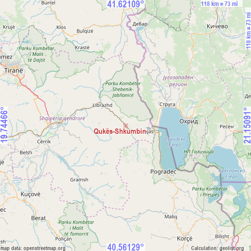
Qukës-Shkumbin GPS coordinates[2]
41° 5' 35.988" North, 20° 26' 52.008" East
| Map corner | latitude | longitude |
|---|---|---|
| Upper-left | 41.62109°, | 19.74466° |
| Center: | 41.09333°, | 20.44778° |
| Lower-right: | 40.56129°, | 21.15091° |
| Map W x H: | 117.8×117.8 km | = 73.2×73.2mi |
| max Lat: | 42.45139° ⇑46.2% North |
| Qukës-Shkumbin: | 41.09333° |
| min Lat: | ⇓53.8% South 39.65889° |
| min Long | Qukës-Shkumbin | max Long |
| 19.40556° | 20.44778° | 20.99° |
| W 87%⇐ | ⇒13% E |
Elevation
Elevation of Qukës-Shkumbin is 449 m = 1473 ft, and this is 74.4 m = 244 ft above average elevation for this country.
| Max E: |
1352 m = 4436 ft | 36.9% |
| Qukës-Shkumbin | 449 m 1473 ft | |
| Avg. | 374.6 m = 1229 ft | |
Min E: |
-2 m = -7 ft | 63.1% |
See also: Albania elevation on elevation.city.
Geographical zone
Qukës-Shkumbin is located in North temperate zone (between Tropic of Cancer and the Arctic Circle). Distance of this Northern Tropic circle is 1963.2 km =1219.9 mi to South.| Distance of | km | miles | from Qukës-Shkumbin |
|---|---|---|---|
| North Pole | 5437.9 | 3379 | to North |
| Arctic Circle | 2832 | 1759.7 | to North |
| Tropic Cancer | 1963.2 | 1219.9 | to South |
| Equator | 4569.1 | 2839.1 | to South |


Nearby cities:
15 places around Qukës-Shkumbin: (largest is in red/bold)
• Gostimë
18.3 km =11.4 mi,  288°
288°
• Hotolisht
8.2 km =5.1 mi,  328°
328°
• Librazhd
14.7 km =9.1 mi,  310°
310°
• Librazhd-Qendër
14.9 km =9.3 mi,  320°
320°
• Polis-Gostimë
16.5 km =10.3 mi, 285°
• Poroçan
21 km =13 mi,  216°
216°
• Proptisht
12.8 km =8 mi,  158°
158°
• Përrenjas
8.8 km =5.5 mi,  104°
104°
• Përrenjas-Fshat
7.9 km =4.9 mi,  112°
112°
• Qukës-Skënderbe
1.3 km =0.8 mi, 217°
• Rajcë
10.8 km =6.7 mi,  91°
91°
• Stravaj
10 km =6.2 mi,  191°
191°
• Udënisht
21.6 km =13.4 mi,  131°
131°
• Velçan
15.5 km =9.6 mi,  175°
175°
• Zavalinë
18.8 km =11.7 mi,  228°
228°
Sources, notices
• [Note1] Compared only with cities in Albania existing in our database
• [Src1] Map data: © OpenStreetMap contributors (CC-BY-SA)
• [Src2] Other city data from geonames.org with taken over terms of usage.
• [Src3] Geographical zone / Annual Mean Temperature by Robert A. Rohde @ Wikipedia
